Ford, Virginia
| Ford, Virginia | |
|---|---|
| Unincorporated community | |
 Ford  Ford | |
| Coordinates: 37°08′58″N 77°44′08″W / 37.14944°N 77.73556°WCoordinates: 37°08′58″N 77°44′08″W / 37.14944°N 77.73556°W | |
| Country | United States |
| State | Virginia |
| County | Dinwiddie |
| Elevation | 308 ft (94 m) |
| Time zone | Eastern (EST) (UTC-5) |
| • Summer (DST) | EDT (UTC-4) |
| ZIP code | 23850 |
| Area code(s) | 804 |
| GNIS feature ID | 1466754[1] |
Ford is an unincorporated community in Dinwiddie County, Virginia, United States. Ford is located on U.S. Route 460 19.2 miles (30.9 km) west-southwest of Petersburg. Ford has a post office with ZIP code 23850.[2]
References
- ↑ "Ford". Geographic Names Information System. United States Geological Survey.
- ↑ United States Postal Service (2012). "USPS - Look Up a ZIP Code". Retrieved 2012-02-15.
Municipalities and communities of Dinwiddie County, Virginia, United States | ||
|---|---|---|
| Town | 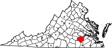 | |
| Unincorporated communities | ||
This article is issued from Wikipedia - version of the 7/27/2016. The text is available under the Creative Commons Attribution/Share Alike but additional terms may apply for the media files.