Forciolo
| Forciolo | |
|---|---|
|
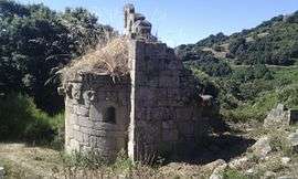
The chapel of San Petru di Panacali, in Forciolo | |
 Forciolo | |
|
Location within Corsica region  Forciolo | |
| Coordinates: 41°51′18″N 9°00′36″E / 41.855°N 9.01°ECoordinates: 41°51′18″N 9°00′36″E / 41.855°N 9.01°E | |
| Country | France |
| Region | Corsica |
| Department | Corse-du-Sud |
| Arrondissement | Ajaccio |
| Canton | Santa-Maria-Siché |
| Intercommunality | Le Taravu |
| Government | |
| • Mayor (2008–2014) | Jean-Pierre Bozzi |
| Area1 | 6.88 km2 (2.66 sq mi) |
| Population (2008)2 | 76 |
| • Density | 11/km2 (29/sq mi) |
| Time zone | CET (UTC+1) |
| • Summer (DST) | CEST (UTC+2) |
| INSEE/Postal code | 2A117 / 20190 |
| Elevation |
231–753 m (758–2,470 ft) (avg. 300 m or 980 ft) |
|
1 French Land Register data, which excludes lakes, ponds, glaciers > 1 km² (0.386 sq mi or 247 acres) and river estuaries. 2 Population without double counting: residents of multiple communes (e.g., students and military personnel) only counted once. | |
Forciolo is a commune in the Corse-du-Sud department of France on the island of Corsica.
Population
| Historical population | ||
|---|---|---|
| Year | Pop. | ±% |
| 1962 | 124 | — |
| 1968 | 132 | +6.5% |
| 1975 | 106 | −19.7% |
| 1982 | 75 | −29.2% |
| 1990 | 56 | −25.3% |
| 1999 | 69 | +23.2% |
| 2008 | 76 | +10.1% |
See also
References
| Wikimedia Commons has media related to Forciolo. |
This article is issued from Wikipedia - version of the 2/11/2016. The text is available under the Creative Commons Attribution/Share Alike but additional terms may apply for the media files.