Flowing Springs, Arizona
| Flowing Springs, Arizona | |
|---|---|
| Census-designated place | |
 Flowing Springs  Flowing Springs | |
| Coordinates: 34°18′55″N 111°20′04″W / 34.31528°N 111.33444°WCoordinates: 34°18′55″N 111°20′04″W / 34.31528°N 111.33444°W | |
| Country | United States |
| State | Arizona |
| County | Gila |
| Area[1] | |
| • Total | 1.709 sq mi (4.43 km2) |
| • Land | 1.707 sq mi (4.42 km2) |
| • Water | 0.002 sq mi (0.005 km2) |
| Elevation | 4,606 ft (1,404 m) |
| Population (2010) | |
| • Total | 42 |
| • Density | 25/sq mi (9.5/km2) |
| Time zone | Mountain (MST) (UTC-7) |
| Area code(s) | 928 |
| GNIS feature ID | 40834[2] |
Flowing Springs is a census-designated place in Gila County in the state of Arizona. Flowing Springs is located about 8 miles north of the town of Payson. The population as of the 2010 U.S. Census was 42.[3]
Geography
Flowing Springs is located at 34°18′33″N 111°20′05″W / 34.309304°N 111.334731°W.
The community has an area of 1.709 square miles (4.43 km2); 1.707 square miles (4.42 km2) of its area is land, and 0.002 square miles (0.0052 km2) is water.[1]
References
Municipalities and communities of Gila County, Arizona, United States | ||
|---|---|---|
| City | 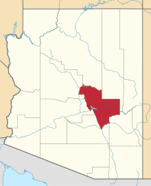 | |
| Towns | ||
| CDPs |
| |
| Unincorporated communities | ||
| Indian reservations | ||
| Ghost towns | ||
| Footnotes | ‡This populated place also has portions in an adjacent county or counties | |
This article is issued from Wikipedia - version of the 10/31/2016. The text is available under the Creative Commons Attribution/Share Alike but additional terms may apply for the media files.