Engenville
| Engenville | ||
|---|---|---|
| ||
 Engenville | ||
|
Location within Centre-Val de Loire region 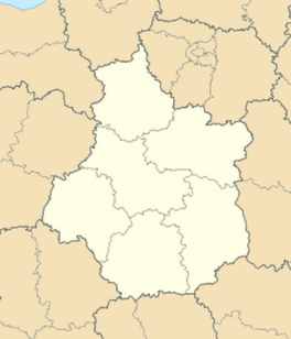 Engenville | ||
| Coordinates: 48°14′20″N 2°14′48″E / 48.2389°N 2.2467°ECoordinates: 48°14′20″N 2°14′48″E / 48.2389°N 2.2467°E | ||
| Country | France | |
| Region | Centre-Val de Loire | |
| Department | Loiret | |
| Arrondissement | Pithiviers | |
| Canton | Malesherbes | |
| Intercommunality | Communauté de communes du Plateau Beauceron | |
| Government | ||
| • Mayor (2001–2008) | Dominique Mameaux | |
| Area1 | 18.10 km2 (6.99 sq mi) | |
| Population (2006)2 | 452 | |
| • Density | 25/km2 (65/sq mi) | |
| Time zone | CET (UTC+1) | |
| • Summer (DST) | CEST (UTC+2) | |
| INSEE/Postal code | 45133 / 45300 | |
| Elevation | 119–136 m (390–446 ft) | |
| Website | www.engenville.com | |
|
1 French Land Register data, which excludes lakes, ponds, glaciers > 1 km² (0.386 sq mi or 247 acres) and river estuaries. 2 Population without double counting: residents of multiple communes (e.g., students and military personnel) only counted once. | ||
.svg.png)
Engenville is a commune in the Loiret department in north-central France.
See also
| Wikimedia Commons has media related to Engenville. |
This article is issued from Wikipedia - version of the 3/15/2016. The text is available under the Creative Commons Attribution/Share Alike but additional terms may apply for the media files.