Chaingy
| Chaingy | ||
|---|---|---|
|
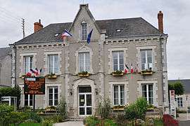
The town hall in Chaingy | ||
| ||
 Chaingy | ||
|
Location within Centre-Val de Loire region  Chaingy | ||
| Coordinates: 47°53′04″N 1°46′25″E / 47.8844°N 1.7736°ECoordinates: 47°53′04″N 1°46′25″E / 47.8844°N 1.7736°E | ||
| Country | France | |
| Region | Centre-Val de Loire | |
| Department | Loiret | |
| Arrondissement | Orléans | |
| Canton | Meung-sur-Loire | |
| Intercommunality | Syndicat Mixte du Pays Loire Beauce | |
| Government | ||
| • Mayor (2008–2014) | Jean-Pierre Durand | |
| Area1 | 21.69 km2 (8.37 sq mi) | |
| Population (2012)2 | 3,551 | |
| • Density | 160/km2 (420/sq mi) | |
| Time zone | CET (UTC+1) | |
| • Summer (DST) | CEST (UTC+2) | |
| INSEE/Postal code | 45067 / 45380 | |
| Elevation | 82–124 m (269–407 ft) | |
| Website | www.chaingy.fr | |
|
1 French Land Register data, which excludes lakes, ponds, glaciers > 1 km² (0.386 sq mi or 247 acres) and river estuaries. 2 Population without double counting: residents of multiple communes (e.g., students and military personnel) only counted once. | ||
.svg.png)
Chaingy is a commune in the Loiret department in north-central France.
See also
| Wikimedia Commons has media related to Chaingy. |
This article is issued from Wikipedia - version of the 7/6/2015. The text is available under the Creative Commons Attribution/Share Alike but additional terms may apply for the media files.