Diablo, Washington
| Diablo, Washington | |
|---|---|
| Unincorporated community | |
 Diablo, Washington | |
| Coordinates: 48°42′48″N 121°08′28″W / 48.71333°N 121.14111°WCoordinates: 48°42′48″N 121°08′28″W / 48.71333°N 121.14111°W | |
| Country | United States |
| State | Washington |
| County | Whatcom |
| Elevation | 896 ft (273 m) |
| Time zone | Pacific (PST) (UTC-8) |
| • Summer (DST) | PDT (UTC-7) |
| Area code(s) | 360 |
| GNIS feature ID | 1518740[1] |
| Highways | none |
Diablo is an unincorporated community in Whatcom County, Washington, United States.[1] The community, which is located on the Skagit River near the Diablo Dam, was established as a company town by Seattle City Light.[2]
References
- 1 2 "Diablo, Whatcom, County, Washington". Geographic Names Information System. United States Geological Survey.
- ↑ Kirk, Ruth (1995). Exploring Washington's Past: A Road Guide to History. University of Washington Press. p. 235. ISBN 9780295974439.
Municipalities and communities of Whatcom County, Washington, United States | ||
|---|---|---|
| Cities | 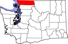 | |
| CDPs | ||
| Indian reservations | ||
| Unincorporated communities | ||
| Ghost towns | ||
This article is issued from Wikipedia - version of the 9/5/2016. The text is available under the Creative Commons Attribution/Share Alike but additional terms may apply for the media files.