Deir Qanun
| Deir Qanun دير قانون | |
|---|---|
| Village | |
 Deir Qanun | |
| Coordinates: 33°36′18″N 36°8′8″E / 33.60500°N 36.13556°E | |
| Country |
|
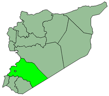
| Governorate | Rif Dimashq Governorate |
| District | Qudsaya District |
| Nahiyah | Ain al-Fijah |
| Population (2004 census)[1] | |
| • Total | 4,213 |
| Time zone | EET (UTC+2) |
| • Summer (DST) | EEST (UTC+3) |
| Area code(s) | 11 |
Deir Qanun (Arabic: دير قانون) is a village in southern Syria, administratively part of the Rif Dimashq Governorate, located northwest of Damascus in the Wadi Barada. Nearby localities include Ain al-Fijah, Deir Muqaran, al-Dimas, Jdeidat al-Wadi, Kfeir al-Zayt and Basimah. According to the Syria Central Bureau of Statistics, Deir Qanun had a population of 4,213 in the 2004 census.[1] Its inhabitants are predominantly Sunni Muslims.[2]
History
Deir Qanun was visited by Syrian geographer Yaqut al-Hamawi in the early 13th-century, during Ayyubid rule. He noted that it was a village "in the neighborhood of Damascus."[3]
References
- 1 2 General Census of Population and Housing 2004. Syria Central Bureau of Statistics (CBS). Rif Dimashq Governorate. (Arabic)
- ↑ Smith, 1841, p. 147.
- ↑ le Strange, 1890, p. 429.
Bibliography
- Smith, Eli; Robinson, Edward (1841). Biblical Researches in Palestine, Mount Sinai and Arabia Petraea: A Journal of Travels in the Year 1838. 3. Crocker and Brewster.
- le Strange, Guy (1890). Palestine Under the Moslems: A Description of Syria and the Holy Land from A.D. 650 to 1500. Committee of the Palestine Exploration Fund.
This article is issued from Wikipedia - version of the 9/28/2016. The text is available under the Creative Commons Attribution/Share Alike but additional terms may apply for the media files.