Darfork, Kentucky
| Darfork | |
|---|---|
| Unincorporated community | |
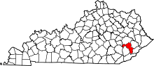
 Darfork  Darfork Location within the state of Kentucky | |
| Coordinates: 37°17′2″N 83°11′15″W / 37.28389°N 83.18750°WCoordinates: 37°17′2″N 83°11′15″W / 37.28389°N 83.18750°W | |
| Country | United States |
| State | Kentucky |
| County | Perry |
| Elevation | 837 ft (255 m) |
| Time zone | Central (CST) (UTC-6) |
| • Summer (DST) | CST (UTC-5) |
| GNIS feature ID | 490590[1] |
Darfork is an unincorporated community and coal town in Perry County, Kentucky, United States. Their Post Office [2] has been closed.
References
This article is issued from Wikipedia - version of the 7/27/2016. The text is available under the Creative Commons Attribution/Share Alike but additional terms may apply for the media files.