Dabneys, Virginia
| Dabneys, Virginia | |
|---|---|
| Unincorporated community | |
 Dabneys, Virginia  Dabneys, Virginia | |
| Coordinates: 37°45′49″N 77°48′06″W / 37.76361°N 77.80167°WCoordinates: 37°45′49″N 77°48′06″W / 37.76361°N 77.80167°W | |
| Country | United States |
| State | Virginia |
| County | Louisa |
| Elevation | 295 ft (90 m) |
| Time zone | Eastern (EST) (UTC-5) |
| • Summer (DST) | EDT (UTC-4) |
| Area code(s) | 540 |
| GNIS feature ID | 1492831[1] |
Dabneys is an unincorporated community in Louisa County, Virginia, United States. Dabneys is 11 miles (18 km) west-northwest of Wyndham.
References
Municipalities and communities of Louisa County, Virginia, United States | ||
|---|---|---|
| Towns | 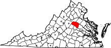 | |
| CDP | ||
| Unincorporated communities |
| |
| Footnotes | ‡This populated place also has portions in an adjacent county or counties | |
This article is issued from Wikipedia - version of the 7/27/2016. The text is available under the Creative Commons Attribution/Share Alike but additional terms may apply for the media files.