D35 road (Croatia)
| |
|---|---|
| Route information | |
| Length: | 46.0 km (28.6 mi) |
| Major junctions | |
| From: |
|
|
| |
| To: |
|
| Location | |
| Counties: | Krapina-Zagorje, Varaždin |
| Major cities: | Varaždin, Ivanec, Lepoglava |
| Highway system | |
| State roads in Croatia | |

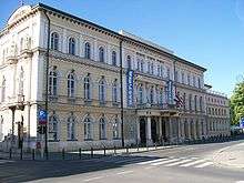
Varaždin, near the northern terminus of the D35 road
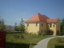
Ivanec, on the D35 road route
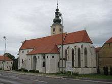
Lepoglava, on the D35 road route
D35 is a state road in the northwestern Croatia connecting Sveti Križ Začretje and the A2 motorway Sveti Križ Začretje interchange to Varaždin and the A4 motorway Varaždin interchange.[1][maps 1] The road is 46.0 km (28.6 mi) long.[2]
The road, as well as all other state roads in Croatia, is managed and maintained by Hrvatske ceste, state owned company.[3]
Traffic volume
Traffic is regularly counted and reported by Hrvatske ceste, operator of the road.[4]
| D35 traffic volume | ||||
| Road | Counting site | AADT | ASDT | Notes |
| |
1213 Greda | 5,250 | 4,936 | Adjacent to the Ž2063 junction. Average daily traffic figure is provided instead of AADT. |
| |
1216 Kaniža - west | 4,294 | 4,548 | Between the Ž2084 and Ž2102 junctions. |
| |
1123 Gornja Šemnica | 1,938 | 1,670 | Between the Ž122 and Ž2122 junction. The AADT figure estimated by Hrvatske ceste. |
Road junctions and populated areas
| D35 junctions/populated areas | |
| Type | Slip roads/Notes |
| |
Nedeljanec Ž2061 to Krkanec and Tužno. The eastern terminus of the road. |
| |
Vidovec |
| |
Jurketinec |
| |
Ž2029 to Biljevec and Vinica. |
| |
Greda |
| |
Ž2063 to Tužno, Črešnjevo and Beretinec. |
| |
Ž2059 to Koškovec and Klenovnik. |
| |
Ž2105 to Salinovec, Pece and Završje Podbelsko. |
| |
Ž2104 to Punikve. |
| |
Ivanec Ž2103 within the town. Ž2085 to Prigorec |
| |
Kaniža Ž2084 to Dubrovec. |
| |
Lepoglava Ž2101 to Bedenec and Jerovec. Ž2102 within the town. |
| |
Muričevec |
| |
Novi Golubovec |
| |
Ž2127 to Gora Veternička. |
| |
Kuzminec |
| |
Ž2125 to Mihovljan and Sutinske Toplice. |
| |
Ž2122 to Radoboj, Trški Vrh and Krapina (D1). |
| |
Donja Šemnica |
| |
Ž2240 to Lepajci (D1). |
| |
Švaljkovec Ž2160 to Sveti Križ Začretje. The western terminus of the road. |
Maps
- ↑ Overview map of the D35 (Map). OpenStreetMap. Retrieved July 24, 2014.
Sources
- 1 2 3 "Regulation on motorway markings, chainage, interchange/exit/rest area numbers and names". Narodne novine (in Croatian). April 24, 2003.
- ↑ Ministry of Sea, Transport and Infrastructure (Croatia) (June 4, 2013). "Decision on categorization of public roads" (in Croatian). Narodne novine. Retrieved July 24, 2014.
- ↑ "Public Roads Act". Narodne novine (in Croatian). December 14, 2004.
- ↑ "Traffic counting on the roadways of Croatia in 2013 - digest" (PDF). Hrvatske ceste. May 2014. Retrieved 2014-07-24.
- 1 2 "Map of border crossings and customs office areas" (PDF). Customs Administration of the Republic of Croatia (in Croatian). March 6, 2008.
This article is issued from Wikipedia - version of the 6/5/2015. The text is available under the Creative Commons Attribution/Share Alike but additional terms may apply for the media files.