D126 road (Croatia)
| |
|---|---|
| Route information | |
| Length: | 8.3 km (5.2 mi) |
| Major junctions | |
| From: |
|
| To: | Slatine |
| Location | |
| Counties: | Split-Dalmatia |
| Highway system | |
| State roads in Croatia | |

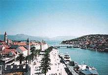
Trogir, at the northern terminus of the D126 road, the Čiovo Bridge is visible
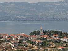
Slatine, at the southern terminus of the D126 road
D315 is a state road branching off from D409 state road connecting it to Trogir. The road is 8.3 km (5.2 mi) long.[1]
In Trogir, the road crosses from the mainland to Čiovo Island via a movable bridge. A new movable bridge is planned to be completed outside the city centre, and at such time, the D126 route is expected to be relocated as well.[2][3][4] The construction appears to be delayed though.
The road, as well as all other state roads in Croatia, is managed and maintained by Hrvatske ceste, a state-owned company.[5]
Road junctions
| D126 junctions | |
| Type | Slip roads/Notes |
| |
Trogir Ž6134 to Okrug Gornji. The northern terminus of the road. |
| |
Mastrinka |
| |
Ž6135 to Žedno. |
| |
Arbanija |
| |
Slatine The southern terminus of the road. |
Sources
- ↑ "Decision on categorization of public roads as state roads, county roads and local roads". Narodne novine (in Croatian). February 17, 2010.
- ↑ Marko Biočina (18 February 2008). "Novi most Trogir - Čiovo" [New Trogir-Čiovo Bridge]. Nacional (in Croatian). Archived from the original on 22 July 2012. Retrieved 22 July 2012.
- ↑ "Trogir-Čiovo Bridge construction starts in 2009". Slobodna Dalmacija (in Croatian). November 11, 2008.
- ↑ "Čiovo Bridge construction starts in a year". Jutarnji list (in Croatian). June 26, 2008. Archived from the original on 2012-10-11.
- ↑ "Public Roads Act". Narodne novine (in Croatian). December 14, 2004.
This article is issued from Wikipedia - version of the 12/4/2016. The text is available under the Creative Commons Attribution/Share Alike but additional terms may apply for the media files.