Currimao
| Currimao | ||
|---|---|---|
| Municipality | ||
| ||
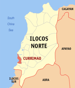 Map of Ilocos Norte showing the location of Currimao | ||
.svg.png) Currimao Location within the Philippines | ||
| Coordinates: 18°01′N 120°29′E / 18.017°N 120.483°ECoordinates: 18°01′N 120°29′E / 18.017°N 120.483°E | ||
| Country | Philippines | |
| Region | Ilocos (Region I) | |
| Province | Ilocos Norte | |
| District | 2nd District | |
| Barangays | 23 | |
| Government[1] | ||
| • Mayor | Rosario C. Go | |
| Area[2] | ||
| • Total | 34.08 km2 (13.16 sq mi) | |
| Population (2010)[3] | ||
| • Total | 11,970 | |
| • Density | 350/km2 (910/sq mi) | |
| Time zone | PST (UTC+8) | |
| ZIP code | 2903 | |
| Dialing code | +63 (0)77 | |
| Income class | 4th class; rural | |

Currimao is a fourth class municipality in the province of Ilocos Norte, Philippines. According to the 2010 census, it had a population of 11,970 people.[3] Surrounded by Pinili in the south, Batac in the east, South China Sea in the west, and Paoay in the north.
Barangays
Currimao is politically subdivided into 23 barangays.[2]
- Anggapang Norte
- Anggapang Sur
- Bimmanga
- Cabuusan
- Comcomloong
- Gaang
- Lang-ayan-Baramban
- Lioes
- Maglaoi Centro
- Maglaoi Norte
- Maglaoi Sur
- Paguludan-Salindeg
- Pangil
- Pias Norte
- Pias Sur
- Poblacion I
- Poblacion II
- Salugan
- San Simeon
- Santa Cruz
- Tapao-Tigue
- Torre
- Victoria
Demographics
| Population census of Currimao | ||
|---|---|---|
| Year | Pop. | ±% p.a. |
| 1990 | 9,467 | — |
| 1995 | 10,133 | +1.28% |
| 2000 | 10,615 | +1.00% |
| 2007 | 11,305 | +0.87% |
| 2010 | 11,970 | +2.10% |
| Source: National Statistics Office[3][4] | ||
References
- ↑ "Official City/Municipal 2013 Election Results". Intramuros, Manila, Philippines: Commission on Elections (COMELEC). 11 September 2013. Retrieved 26 September 2013.
- 1 2 "Province: ILOCOS NORTE". PSGC Interactive. Makati City, Philippines: National Statistical Coordination Board. Archived from the original on 27 September 2013. Retrieved 26 September 2013.
- 1 2 3 "Total Population by Province, City, Municipality and Barangay: as of May 1, 2010" (PDF). 2010 Census of Population and Housing. National Statistics Office. Archived from the original (PDF) on 15 November 2012. Retrieved 26 September 2013.
- ↑ "Province of Ilocos Norte". Municipality Population Data. LWUA Research Division. Retrieved 25 September 2013.
External links
- Pasyalan Ilocos Norte
- Philippine Standard Geographic Code
- Philippine Census Information
- Local Governance Performance Management System
 |
Paoay | | ||
| South China Sea | |
Batac | ||
| ||||
| | ||||
| Pinili |
Laoag (capital) | |
| Municipalities | |
| Component cities | |
| Barangays | |
This article is issued from Wikipedia - version of the 12/3/2016. The text is available under the Creative Commons Attribution/Share Alike but additional terms may apply for the media files.