Corvuso, Minnesota
| Corvuso, Minnesota | |
|---|---|
| Unincorporated community | |
 Corvuso, Minnesota  Corvuso, Minnesota Location of the community of Corvuso | |
| Coordinates: 44°56′10″N 94°36′17″W / 44.93611°N 94.60472°WCoordinates: 44°56′10″N 94°36′17″W / 44.93611°N 94.60472°W | |
| Country | United States |
| State | Minnesota |
| County | Meeker |
| Township | Cedar Mills Township |
| Elevation | 1,099 ft (335 m) |
| Time zone | Central (CST) (UTC-6) |
| • Summer (DST) | CDT (UTC-5) |
| ZIP code | 56228 and 55355 |
| Area code(s) | 320 |
| GNIS feature ID | 641516[1] |
Corvuso is an unincorporated community in Cedar Mills Township, Meeker County, Minnesota, United States. The community is located along Meeker County Road 1 near State Highway 7 (MN 7). The South Fork of the Crow River flows nearby.
Nearby places include Cosmos, Litchfield, and Hutchinson.
References
Municipalities and communities of Meeker County, Minnesota, United States | ||
|---|---|---|
| Cities | 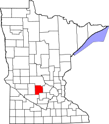 | |
| Townships | ||
| Unincorporated communities | ||
| Footnotes | ‡This populated place also has portions in an adjacent county or counties | |
This article is issued from Wikipedia - version of the 7/28/2016. The text is available under the Creative Commons Attribution/Share Alike but additional terms may apply for the media files.