Conway Township, Michigan
Not to be confused with an unincorporated community named Conway, Michigan in Emmet County.
| Conway Township, Michigan | |
|---|---|
| Township | |
 Conway Township, Michigan Location within the state of Michigan | |
| Coordinates: 42°43′31″N 84°6′21″W / 42.72528°N 84.10583°WCoordinates: 42°43′31″N 84°6′21″W / 42.72528°N 84.10583°W | |
| Country | United States |
| State | Michigan |
| County | Livingston |
| Area | |
| • Total | 37.8 sq mi (97.9 km2) |
| • Land | 37.8 sq mi (97.8 km2) |
| • Water | 0.0 sq mi (0.1 km2) |
| Elevation | 899 ft (274 m) |
| Population (2010) | |
| • Total | 3,546 |
| • Density | 93.8/sq mi (36.2/km2) |
| Time zone | Eastern (EST) (UTC-5) |
| • Summer (DST) | EDT (UTC-4) |
| FIPS code | 26-17920[1] |
| GNIS feature ID | 1626130[2] |
| Website | http://www.conwaytownship.com/ |
Conway Township is a civil township of Livingston County in the U.S. state of Michigan. The population was 3,546 at the 2010 census, an increase of 814 over 2000.
Communities
- Nicholson is an unincorporated community in the township on E. Lovejoy Road (border road with Shiawassee County) between State and Nohel roads. 42°46′37″N 84°07′26″W / 42.77694°N 84.12389°W[3][4]
Geography
According to the United States Census Bureau, the township has a total area of 37.8 square miles (98 km2), of which 37.8 square miles (98 km2) is land and 0.04 square miles (0.10 km2) (0.08%) is water.
Demographics
| 2010 Census and American Community Survey[5] | 2000 Census and American Community Survey[1] | Increase | |
|---|---|---|---|
| Total Population | 3,546 | 2,732 | 814 (29.8%) |
| Total Households | 1,199 | 887 | 312 (35.1%) |
| Total Families | 968 | 748 | 220 (29.4%) |
| Population Density | 93.8/mi² (36.2/km²) | 72.3/mi² (27.9/km²) | 21.5/mi² (8.3/km²) (29.7%) |
| Total Housing Units | 1,264 | 919 | 345 (37.5%) |
| Housing Unit Density | 33.4/mi² (12.9/km²) | 24.3/mi² (9.4/km²) | 9.1/mi² (3.5/km²) (37.2%) |
| Racial Makeup | |||
| White | 96.4% | 95.7% | 0.7% |
| African American | 0.3% | 0.3% | 0% |
| Native American | 0.8% | 1.4% | -0.6% |
| Asian | 0.8% | 0.2% | 0.6% |
| Other | 0.1% | 0.6% | -0.5% |
| Two or More Races | 1.6% | 1.7% | -0.1% |
| Hispanic or Latino of any race | 1.7% | 1.3% | 0.4% |
| Household Makeup | |||
| Households with children under 18 | 38% | 45.7% | -7.7% |
| Married | 66.2 | 75.3% | -9.1% |
| Female householder, no husband present | 8.5% | 6.2% | 2.3% |
| Male householder, no wife present | 6% | ? | ? |
| Non-families | 19.3% | 15.6% | 3.7% |
| Individual living alone | 15.2% | 12.6% | 2.6% |
| Individual living alone, 65 and over | 5.5% | 4.2% | 1.3% |
| Average Household Size | 2.95 | 3.08 | -0.13 |
| Average Family Size | 3.28 | 3.38 | -0.1 |
| Age and Gender Makeup | |||
| Less than 18 | 28.9% | 31.3% | -2.4% |
| 18 to 24 | 7.4% | 7.1% | 0.3% |
| 25 to 44 | 27.1% | 32.7% | -5.6 |
| 45 to 64 | 28.3% | 21.6% | 6.7% |
| Over 65 | 8.5% | 7.4% | 1.1% |
| Median Age | 37 | 35 | 2 |
| Males (Total) | 52.1% | 51.7% | 0.4% |
| Males (18 and over) | 51.4% | 51.0% | 0.4% |
| Income | |||
| Household Median Annual Income | $68,077 | $64,306 | $3,711 (5.9%) |
| Family Median Annual Income | $76,638 | $67,206 | $9,432 (14%) |
| Male Median Annual Income | $63,125 | $49,392 | $13,733 (27.8%) |
| Female Median Annual Income | $40,469 | $27,813 | $12,656 (45.5%) |
| Per Capita Income | $25,751 | $23,796 | $1,982 (8.3%) |
| Below Poverty Line | |||
| Families | 8.5% | 2.3% | 6.2% (3.7x 2000 percentage) |
| Population | 10.9% | 4.1% | 6.8% (2.7x 2000 percentage) |
| Under 18 | 13.3% | 6.1% | 7.2% (2.2x 2000 percentage) |
| 65 and Over | 6.7% | 6.6% | 0.1% |
References
- 1 2 "American FactFinder". United States Census Bureau. Archived from the original on 2013-09-11. Retrieved 2008-01-31.
- ↑ U.S. Geological Survey Geographic Names Information System: Conway Township, Michigan
- ↑ U.S. Geological Survey Geographic Names Information System: Nicholson, Michigan
- ↑ LIVINGSTON_COUNTY County Map. State of Michigan Department of Technology, Management and Budget. 08/05/2010.
- ↑ American FactFinder. United States Census Bureau. Accessed November 6, 2012.
External links
Municipalities and communities of Livingston County, Michigan, United States | ||
|---|---|---|
| Cities | 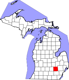 | |
| Villages | ||
| Charter townships | ||
| General law townships | ||
| Unincorporated communities |
| |
| Footnotes | ‡This populated place also has portions in an adjacent county or counties | |
This article is issued from Wikipedia - version of the 11/30/2016. The text is available under the Creative Commons Attribution/Share Alike but additional terms may apply for the media files.