Coney Island, Minnesota
| Coney Island, Minnesota | |
|---|---|
| Unincorporated community | |
|
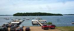
The namesake lake island | |
 Coney Island, Minnesota  Coney Island, Minnesota Location of the community of Coney Island | |
| Coordinates: 44°51′18″N 93°45′41″W / 44.85500°N 93.76139°WCoordinates: 44°51′18″N 93°45′41″W / 44.85500°N 93.76139°W | |
| Country | United States |
| State | Minnesota |
| County | Carver |
| Township | Laketown Township |
| Elevation | 971 ft (296 m) |
| Time zone | Central (CST) (UTC-6) |
| • Summer (DST) | CDT (UTC-5) |
| ZIP code | 55387 |
| Area code(s) | 952 |
| GNIS feature ID | 1815278[1] |
Coney Island is an unincorporated community in Laketown Township, Carver County, Minnesota, United States. The community is located along Highway 5 at Laketown Parkway near Waconia and St. Bonifacius.
Coney Island took its name from a nearby lake island, which was a popular summer resort.[2]
References
- ↑ "Coney Island, Minnesota". Geographic Names Information System. United States Geological Survey.
- ↑ Upham, Warren (1920). Minnesota Geographic Names: Their Origin and Historic Significance. Minnesota Historical Society. p. 82.
Municipalities and communities of Carver County, Minnesota, United States | ||
|---|---|---|
| Cities | 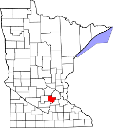 | |
| Townships | ||
| Unincorporated communities | ||
| Ghost town | ||
| Footnotes | ‡This populated place also has portions in an adjacent county or counties | |
This article is issued from Wikipedia - version of the 10/24/2016. The text is available under the Creative Commons Attribution/Share Alike but additional terms may apply for the media files.