Coburn, California
| Coburn | |
|---|---|
| Unincorporated community | |
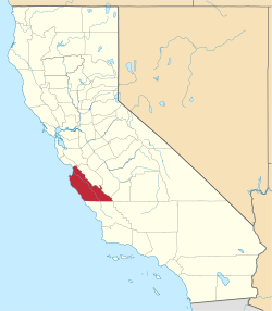
 Coburn Location in California | |
| Coordinates: 36°17′19″N 121°09′10″W / 36.28861°N 121.15278°WCoordinates: 36°17′19″N 121°09′10″W / 36.28861°N 121.15278°W | |
| Country | United States |
| State | California |
| County | Monterey County |
| Elevation[1] | 282 ft (86 m) |
Coburn is an unincorporated community in Monterey County, California.[1] It is located on the Southern Pacific Railroad and County Route G15 5.5 miles (8.9 km) east-southeast of Greenfield,[2] at an elevation of 282 feet (86 m).[1]
The name honors Loren Coburn who in 1883 granted the railroad a right of way on his land.[2]
References
This article is issued from Wikipedia - version of the 11/9/2014. The text is available under the Creative Commons Attribution/Share Alike but additional terms may apply for the media files.