Clive, Utah
| Clive, Utah | |
|---|---|
| Unincorporated community | |
 Clive, Utah  Clive, Utah | |
| Coordinates: 40°42′31″N 113°07′03″W / 40.70861°N 113.11750°WCoordinates: 40°42′31″N 113°07′03″W / 40.70861°N 113.11750°W | |
| Country | United States |
| State | Utah |
| County | Tooele |
| Elevation | 4,288 ft (1,307 m) |
| Time zone | Mountain (MST) (UTC-7) |
| • Summer (DST) | MDT (UTC-6) |
| Area code(s) | 435 |
| GNIS feature ID | 1437527[1] |
Clive is an unincorporated community in Tooele County, Utah, United States.[1] It is located in the western portion of the state, close to the Dugway Proving Grounds. Interstate 80 exit 49 provides access to Clive.
Clive is the site of a radioactive waste storage facility currently operated by EnergySolutions. The facility was built and operated by Envirocare from 1988 until its merger into EnergySolutions in 2007.[2]
References
Municipalities and communities of Tooele County, Utah, United States | ||
|---|---|---|
| Cities | 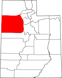 | |
| Towns | ||
| CDPs | ||
| Unincorporated communities | ||
| Ghost towns | ||
This article is issued from Wikipedia - version of the 8/8/2016. The text is available under the Creative Commons Attribution/Share Alike but additional terms may apply for the media files.