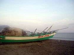
Claveria, Cagayan
| Claveria | ||
|---|---|---|
| Municipality | ||
 | ||
| ||
| Nickname(s): The Top End of Cagayan | ||
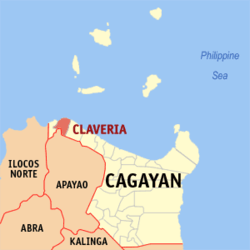 Map of Cagayan showing the location of Claveria | ||
.svg.png) Claveria Location within the Philippines | ||
| Coordinates: 18°36′N 121°05′E / 18.6°N 121.08°ECoordinates: 18°36′N 121°05′E / 18.6°N 121.08°E | ||
| Country | Philippines | |
| Region | Cagayan Valley (Region II) | |
| Province | Cagayan | |
| District | 2nd District | |
| Barangays | 41 | |
| Government[1] | ||
| • Mayor | Pablo N. Bolante Jr. | |
| • Vice-mayor | Solferino A. Agra Jr. | |
| Area[2] | ||
| • Total | 194.8 km2 (75.2 sq mi) | |
| Population (2015 census)[3] | ||
| • Total | 29,921 | |
| • Density | 150/km2 (400/sq mi) | |
| Time zone | PST (UTC+8) | |
| ZIP code | 3519 | |
| IDD : area code | +63 (0)78 | |
| Income class | 3rd class | |
| Website |
www | |

Claveria is a third class municipality in the province of Cagayan, Philippines. According to the 2015 census, it has a population of 29,921 people.[3]
Barangays
Claveria is politically subdivided into 41 barangays.[2]
- Alimoan
- Bacsay Cataraoan Norte
- Bacsay Cataraoan Sur
- Bacsay Mapulapula
- Bilibigao
- Buenavista
- Cadcadir East (former brgy of Santa Praxedes)
- Cadcadir West (former brgy of Santa Praxedes)
- Camalagaoan/D. Leaño
- Capannikian
- Centro I (Poblacion)
- Centro II (Poblacion)
- Centro III (Poblacion)
- Centro IV (Nangasangan)
- Centro V (Mina)
- Centro VI (Minanga)
- Centro VII (Malasin East)
- Centro VIII (Malasin West)
- Culao
- Dibalio
- Kilkiling (former brgy of Santa Praxedes)
- Lablabig (former brgy of Santa Praxedes)
- Luzon
- Mabnang (former brgy of Santa Praxedes)
- Magdalena
- Malilitao
- Nagsabaran
- Pata East
- Pata West
- Pinas
- Santiago
- San Antonio (Sayad/Bimmokel)
- San Isidro
- San Vicente
- Santa Maria
- Santo Niño (Barbarnis)
- Santo Tomas
- Tabbugan
- Taggat Norte
- Taggat Sur
- Union (former brgy of Santa Praxedes)
Demographics
| Population census of Claveria | ||
|---|---|---|
| Year | Pop. | ±% p.a. |
| 1990 | 24,252 | — |
| 1995 | 25,363 | +0.84% |
| 2000 | 29,277 | +3.12% |
| 2007 | 30,275 | +0.46% |
| 2010 | 30,482 | +0.25% |
| 2015 | 29,921 | −0.35% |
| Source: Philippine Statistics Authority[3][4] | ||
In the 2015 census, the population of Claveria, Cagayan, was 29,921 people,[3] with a density of 150 inhabitants per square kilometre or 390 inhabitants per square mile.
References
- ↑ "Official City/Municipal 2013 Election Results". Intramuros, Manila, Philippines: Commission on Elections (COMELEC). 11 September 2013. Retrieved 24 January 2014.
- 1 2 "Province: CAGAYAN". PSGC Interactive. Makati City, Philippines: National Statistical Coordination Board. Retrieved 24 January 2014.
- 1 2 3 4 "Region II (CAGAYAN VALLEY)". Census of Population (2015): Total Population by Province, City, Municipality and Barangay (Report). PSA. Retrieved 20 June 2016.
- ↑ "Region II (CAGAYAN VALLEY)". Census of Population and Housing (2010): Total Population by Province, City, Municipality and Barangay (Report). NSO. Retrieved 29 June 2016.
External links
- Claveria, Cagayan current Photos
- First Unofficial Website of Claveria, Cagayan
- Philippine Standard Geographic Code
- Philippine Census Information
 |
Babuyan Channel (Luzon Strait) | | ||
| Santa Praxedes | |
Sanchez-Mira | ||
| ||||
| | ||||
| Calanasan, Apayao | Luna, Apayao |
Tuguegarao (capital) | |
| Municipalities | |
| Component city | |
| Barangays | |
This article is issued from Wikipedia - version of the 11/26/2016. The text is available under the Creative Commons Attribution/Share Alike but additional terms may apply for the media files.