Clarke, Oregon
| Clarke, Oregon | |
|---|---|
| Unincorporated community | |
 Clarke, Oregon  Clarke, Oregon | |
| Coordinates: 45°50′16″N 119°36′03″W / 45.83778°N 119.60083°WCoordinates: 45°50′16″N 119°36′03″W / 45.83778°N 119.60083°W | |
| Country | United States |
| State | Oregon |
| County | Morrow |
| Elevation | 404 ft (123 m) |
| Time zone | Pacific (PST) (UTC-8) |
| • Summer (DST) | PDT (UTC-7) |
| GNIS feature ID | 1161314[1] |
| Coordinates and elevation from the Geographic Names Information System (GNIS)[1] | |
Clarke is an unincorporated community in Morrow County, Oregon, United States.[1] It lies east of Boardman between Interstate 84 to the south and U.S. Route 730 to the north.[2]
References
Municipalities and communities of Morrow County, Oregon, United States | ||
|---|---|---|
| Cities | 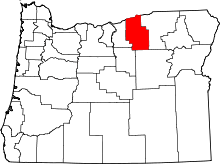 | |
| Unincorporated communities | ||
| Ghost town | ||
This article is issued from Wikipedia - version of the 10/23/2016. The text is available under the Creative Commons Attribution/Share Alike but additional terms may apply for the media files.