Chalkhill, Pennsylvania
| Chalkhill, Pennsylvania Chalk Hill | |
|---|---|
| Census-designated place | |
|
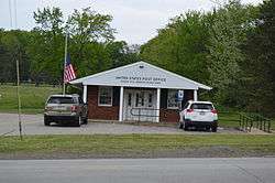
Post office | |
 Chalkhill  Chalkhill | |
| Coordinates: 39°50′46″N 79°36′51″W / 39.84611°N 79.61417°WCoordinates: 39°50′46″N 79°36′51″W / 39.84611°N 79.61417°W | |
| Country | United States |
| State | Pennsylvania |
| County | Fayette |
| Township | Wharton |
| Area | |
| • Total | 0.83 sq mi (2.15 km2) |
| • Land | 0.82 sq mi (2.12 km2) |
| • Water | 0.01 sq mi (0.03 km2) |
| Elevation | 2,060 ft (630 m) |
| Population (2010) | |
| • Total | 141 |
| • Density | 172/sq mi (66.5/km2) |
| Time zone | Eastern (EST) (UTC-5) |
| • Summer (DST) | EDT (UTC-4) |
| ZIP code | 15421 |
| FIPS code | 42-12512 |
| GNIS feature ID | 2631254 |
Chalkhill[1] or Chalk Hill[2] is an unincorporated community and census-designated place in Wharton Township, Fayette County, Pennsylvania, United States. It is located along U.S. Route 40 (the National Road) about 8 miles (13 km) southeast of the city of Uniontown. As of the 2010 census the population was 141.[3]
References
- ↑ U.S. Geological Survey Geographic Names Information System: Chalkhill Census Designated Place
- ↑ U.S. Postal Service, "Default City Name" in ZIP code 15421
- ↑ "Geographic Identifiers: 2010 Census Summary File 1 (G001), Chalkhill CDP, Pennsylvania". American FactFinder. U.S. Census Bureau. Retrieved July 22, 2016.
External links
Municipalities and communities of Fayette County, Pennsylvania, United States | ||
|---|---|---|
| Cities | 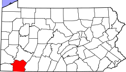 | |
| Boroughs | ||
| Townships | ||
| CDPs | ||
| Unincorporated communities | ||
| Footnotes | ‡This populated place also has portions in an adjacent county or counties | |
This article is issued from Wikipedia - version of the 9/4/2016. The text is available under the Creative Commons Attribution/Share Alike but additional terms may apply for the media files.