Carpiano
| Carpiano | |
|---|---|
| Comune | |
| Comune di Carpiano | |
 Carpiano Location of Carpiano in Italy | |
| Coordinates: 45°20′N 9°16′E / 45.333°N 9.267°ECoordinates: 45°20′N 9°16′E / 45.333°N 9.267°E | |
| Country | Italy |
| Region | Lombardy |
| Province / Metropolitan city | Milan (MI) |
| Frazioni | Draghetto, Francolino, Ortigherio |
| Government | |
| • Mayor | Francesco Ronchi |
| Area | |
| • Total | 17.2 km2 (6.6 sq mi) |
| Elevation | 91 m (299 ft) |
| Population (31 December 2004) | |
| • Total | 2,502 |
| • Density | 150/km2 (380/sq mi) |
| Demonym(s) | Carpianesi |
| Time zone | CET (UTC+1) |
| • Summer (DST) | CEST (UTC+2) |
| Postal code | 20080 |
| Dialing code | 02 |
| Patron saint | St. Martin |
| Saint day | 11 November |
Carpiano is a comune (municipality) in the Province of Milan in the Italian region Lombardy, located about 15 kilometres (9 mi) southeast of Milan. As of 31 December 2004, it had a population of 2,502 and an area of 17.2 square kilometres (6.6 sq mi).[1]
Carpiano borders the following municipalities: San Giuliano Milanese, Locate di Triulzi, Melegnano, Cerro al Lambro, Siziano, Landriano, Bascapè.
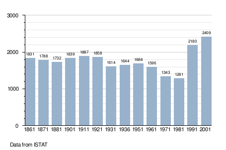
Demographic evolution
References
This article is issued from Wikipedia - version of the 1/31/2015. The text is available under the Creative Commons Attribution/Share Alike but additional terms may apply for the media files.