Cégénydányád
| Cégénydányád | ||
|---|---|---|
| ||
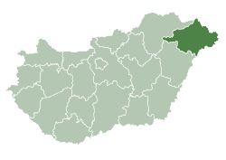
 Cégénydányád Location of Cégénydányád in Hungary | ||
| Coordinates: HU 47°56′N 22°33′E / 47.933°N 22.550°E | ||
| Country |
| |
| County | Szabolcs-Szatmár-Bereg | |
| Area | ||
| • Total | 12.20 km2 (4.71 sq mi) | |
| Population (2001) | ||
| • Total | 735 | |
| • Density | 60.25/km2 (156.0/sq mi) | |
| Time zone | CET (UTC+1) | |
| • Summer (DST) | CEST (UTC+2) | |
| Postal code | 4732 | |
| Area code(s) | 44 | |
| Website |
www | |
Cégénydányád is a village in Szabolcs-Szatmár-Bereg county, in the Northern Great Plain region of eastern Hungary.
Geography
It covers an area of 12.2 km2 (5 sq mi) and has a population of 735 people (2001).
External links
- Official website (Hungarian)
This article is issued from Wikipedia - version of the 5/31/2015. The text is available under the Creative Commons Attribution/Share Alike but additional terms may apply for the media files.