Branch, Louisiana
| Branch, Louisiana | |
|---|---|
| Census-designated place | |
 Branch Location within the state of Louisiana | |
| Coordinates: 30°20′55″N 92°16′3″W / 30.34861°N 92.26750°WCoordinates: 30°20′55″N 92°16′3″W / 30.34861°N 92.26750°W | |
| Country | United States |
| State | Louisiana |
| Parish | Acadia |
| Area | |
| • Total | 7.38 sq mi (19.11 km2) |
| • Land | 7.36 sq mi (19.05 km2) |
| • Water | 0.02 sq mi (0.06 km2) |
| Elevation | 39 ft (12 m) |
| Population (2010) | |
| • Total | 388 |
| • Density | 53/sq mi (20.4/km2) |
| Time zone | Central (CST) (UTC-6) |
| • Summer (DST) | CST (UTC-5) |
| ZIP code | 70516 |
| FIPS code | 22-09235 |
Branch is an unincorporated community and census-designated place in Acadia Parish, Louisiana, United States. As of the 2010 census, it had a population of 388.[1]
Branch is located on LA-35 near the LA-365 intersection, approximately 5 miles (8 km) south of the town of Church Point and 8 miles (13 km) north of the city of Rayne.
References
- ↑ "Geographic Identifiers: 2010 Demographic Profile Data (G001): Branch CDP, Louisiana". U.S. Census Bureau, American Factfinder. Retrieved May 14, 2013.
Municipalities and communities of Acadia Parish, Louisiana, United States | ||
|---|---|---|
| Cities | 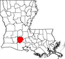 | |
| Towns | ||
| Villages | ||
| CDPs | ||
| Other unincorporated communities |
| |
| Footnotes | ‡This populated place also has portions in an adjacent parish or parishes | |
This article is issued from Wikipedia - version of the 9/2/2015. The text is available under the Creative Commons Attribution/Share Alike but additional terms may apply for the media files.