Blomford, Minnesota
| Blomford, Minnesota | |
|---|---|
| Unincorporated community | |
 Blomford, Minnesota  Blomford, Minnesota Location of the community of Blomford | |
| Coordinates: 45°30′01″N 93°08′33″W / 45.50028°N 93.14250°WCoordinates: 45°30′01″N 93°08′33″W / 45.50028°N 93.14250°W | |
| Country | United States |
| State | Minnesota |
| County | Isanti County |
| Township | North Branch Township and Isanti Township |
| Elevation | 945 ft (288 m) |
| Time zone | Central (CST) (UTC-6) |
| • Summer (DST) | CDT (UTC-5) |
| ZIP code | 55008 and 55040 |
| Area code(s) | 763 |
| GNIS feature ID | 640266[1] |
Blomford is an unincorporated community in Isanti County, Minnesota, United States.
The community is located between Isanti and North Branch at the junction of Isanti County Roads 5 and 12.
Blomford is located within Isanti Township and North Branch Township. Nearby places also include Cambridge and Weber.
References
- Official State of Minnesota Highway Map – 2013/2014 edition
Municipalities and communities of Isanti County, Minnesota, United States | ||
|---|---|---|
| Cities | 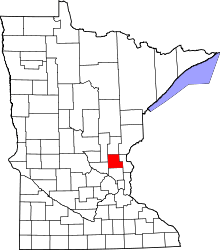 | |
| Townships | ||
| CDP | ||
| Unincorporated communities | ||
| Ghost town | ||
| Footnotes | ‡This populated place also has portions in an adjacent county or counties | |
This article is issued from Wikipedia - version of the 7/28/2016. The text is available under the Creative Commons Attribution/Share Alike but additional terms may apply for the media files.