Berstett
| Berstett Barstett | ||
|---|---|---|
 | ||
| ||
 Berstett | ||
|
Location within Grand Est region  Berstett | ||
| Coordinates: 48°40′48″N 7°39′31″E / 48.68°N 7.6586°ECoordinates: 48°40′48″N 7°39′31″E / 48.68°N 7.6586°E | ||
| Country | France | |
| Region | Grand Est | |
| Department | Bas-Rhin | |
| Arrondissement | Saverne | |
| Canton | Bouxwiller | |
| Intercommunality | Kochersberg | |
| Government | ||
| • Mayor (2008–2014) | Jean-Claude Lasthaus | |
| Area1 | 17.88 km2 (6.90 sq mi) | |
| Population (2009)2 | 2,287 | |
| • Density | 130/km2 (330/sq mi) | |
| Time zone | CET (UTC+1) | |
| • Summer (DST) | CEST (UTC+2) | |
| INSEE/Postal code | 67034 / 67370 | |
| Elevation | 147–281 m (482–922 ft) | |
|
1 French Land Register data, which excludes lakes, ponds, glaciers > 1 km² (0.386 sq mi or 247 acres) and river estuaries. 2 Population without double counting: residents of multiple communes (e.g., students and military personnel) only counted once. | ||

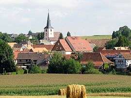
Berstett is a commune in the Bas-Rhin department in Grand Est in northeastern France.
In 1972, the communes of Berstett, Gimbrett, Reitwiller and Rumersheim were merged into the present commune.
Population
| Historical population | ||
|---|---|---|
| Year | Pop. | ±% |
| 1962 | 1,261 | — |
| 1968 | 1,265 | +0.3% |
| 1975 | 1,274 | +0.7% |
| 1982 | 1,527 | +19.9% |
| 1990 | 1,679 | +10.0% |
| 1999 | 1,919 | +14.3% |
| 2006 | 2,053 | +7.0% |
| 2009 | 2,287 | +11.4% |
See also
References
External links
| Wikimedia Commons has media related to Berstett. |
This article is issued from Wikipedia - version of the 11/13/2016. The text is available under the Creative Commons Attribution/Share Alike but additional terms may apply for the media files.