Bennett Township, Kingman County, Kansas
| Bennett Township | |
|---|---|
| Township | |
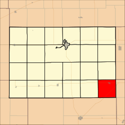 Location in Kingman County | |
| Coordinates: 37°25′45″N 97°51′29″W / 37.42917°N 97.85806°WCoordinates: 37°25′45″N 97°51′29″W / 37.42917°N 97.85806°W | |
| Country | United States |
| State | Kansas |
| County | Kingman |
| Area | |
| • Total | 36.49 sq mi (94.51 km2) |
| • Land | 36.49 sq mi (94.51 km2) |
| • Water | 0 sq mi (0 km2) 0% |
| Elevation | 1,427 ft (435 m) |
| Population (2000) | |
| • Total | 705 |
| • Density | 19.3/sq mi (7.5/km2) |
| GNIS feature ID | 0470280 |
Bennett Township is a township in Kingman County, Kansas, USA. As of the 2000 census, its population was 705.[1]
Geography
Bennett Township covers an area of 36.49 square miles (94.51 square kilometers).
Cities and towns
Adjacent townships
- Allen Township (north)
- Erie Township, Sedgwick County (northeast)
- Eden Township, Sumner County (east)
- Township No. 6 Township, Harper County (southwest)
- Canton Township (west)
- Eagle Township (northwest)
Cemeteries
The township contains two cemeteries: Stitch and Upchurch.
Major highways
Airports and landing strips
- Norwich Landing Strip
References
External links
Municipalities and communities of Kingman County, Kansas, United States | ||
|---|---|---|
| Cities | 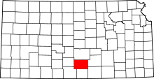 | |
| Unincorporated communities |
| |
| Townships | ||
This article is issued from Wikipedia - version of the 10/31/2016. The text is available under the Creative Commons Attribution/Share Alike but additional terms may apply for the media files.