Baird, Mississippi
| Baird, Mississippi | |
|---|---|
| Unincorporated community | |
|
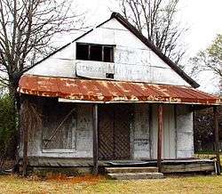
Abandoned store and post office in Baird | |
 Baird, Mississippi  Baird, Mississippi | |
| Coordinates: 33°25′30″N 90°30′00″W / 33.42500°N 90.50000°WCoordinates: 33°25′30″N 90°30′00″W / 33.42500°N 90.50000°W | |
| Country | United States |
| State | Mississippi |
| County | Sunflower |
| Elevation | 118 ft (36 m) |
| Time zone | Central (CST) (UTC-6) |
| • Summer (DST) | CDT (UTC-5) |
| ZIP code | 38751 |
| Area code(s) | 662 |
| GNIS feature ID | 711032[1] |
Baird is an unincorporated community located in Sunflower County, Mississippi, United States.
Baird is approximately 3 miles (4.8 km) west of Moorhead and 10 miles (16 km) southeast of Indianola.
History
The settlement was named for John R. Baird, the former owner of the town site.[2]
In the early 1900s, a station of the Southern Railway was located in Baird.[2] The track has since been removed.
The population in 1900 was 300.[2]
Gallery
-
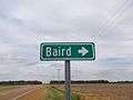
Sign to Baird
References
- ↑ U.S. Geological Survey Geographic Names Information System: Baird, Mississippi
- 1 2 3 Rowland, Dunbar (1907). Mississippi: Comprising Sketches of Counties, Towns, Events, Institutions, and Persons, Arranged in Cyclopedic Form. 1. Southern Historical Publishing Association. p. 179.
Municipalities and communities of Sunflower County, Mississippi, United States | ||
|---|---|---|
| Cities | 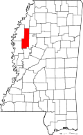 | |
| Towns | ||
| Unincorporated communities | ||
| Ghost towns | ||
| Footnotes | ‡This populated place also has portions in an adjacent county or counties | |
This article is issued from Wikipedia - version of the 7/31/2016. The text is available under the Creative Commons Attribution/Share Alike but additional terms may apply for the media files.