Alto Taquari
| Alto Taquari | |
|---|---|
| Municipality | |
| The Municipality of Alto Taquari | |
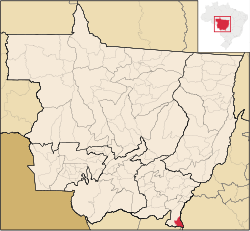 Location of Alto Taquari | |
| Coordinates: 17°49′33″S 53°16′55″W / 17.82583°S 53.28194°WCoordinates: 17°49′33″S 53°16′55″W / 17.82583°S 53.28194°W | |
| Country |
|
| Region | Central-West |
| State |
|
| Founded | May 13, 1986 |
| Government | |
| • Mayor | Lairto João Sperandio (PMBD |
| Area | |
| • Total | 1,394.760 km2 (538.520 sq mi) |
| Elevation | 851 m (17° 49' 33" S 53° 16' 55" O ft) |
| Population (2008) | |
| • Total | 6,321 |
| • Density | 4.0/km2 (10/sq mi) |
| [1] | |
| Time zone | UTC-4 (UTC-4) |
| • Summer (DST) | UTC-3 (UTC-3) |
| HDI (2000) | 0.804 – high[2] |
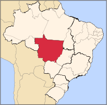
Alto Taquari is the southernmost municipality in the Brazilian state of Mato Grosso.
References
- ↑ IBGE 2008 statistics
- ↑ "Archived copy". Archived from the original on 2009-10-03. Retrieved 2009-12-17. - UNDP
Capital: Cuiabá | |||||||||||||||||||||||||||||||
| Centro-Sul Mato-Grossense |
|  | |||||||||||||||||||||||||||||
| Nordeste Mato-Grossense |
| ||||||||||||||||||||||||||||||
| Norte Mato-Grossense |
| ||||||||||||||||||||||||||||||
| Sudeste Mato-Grossense |
| ||||||||||||||||||||||||||||||
| Sudoeste Mato-Grossense |
| ||||||||||||||||||||||||||||||
This article is issued from Wikipedia - version of the 10/10/2016. The text is available under the Creative Commons Attribution/Share Alike but additional terms may apply for the media files.