Čakovice
| Čakovice (Čakovice) | |||
| Municipal District of Prague Cadastral Area of Prague | |||
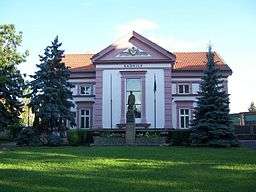 Praha-Čakovice town hall | |||
|
|||
| Official name: Městská část Praha-Čakovice | |||
| Country | Czech Republic | ||
|---|---|---|---|
| Region | Prague, the Capital City | ||
| District | Prague 18 | ||
| Coordinates | 50°9′4″N 14°31′29″E / 50.15111°N 14.52472°ECoordinates: 50°9′4″N 14°31′29″E / 50.15111°N 14.52472°E | ||
| Area | 10.19 km2 (4 sq mi) | ||
| Population | 8,644 (2008) | ||
| Density | 848/km2 (2,196/sq mi) | ||
| Mayor | Alena Samková | ||
| Timezone | CET (UTC+1) | ||
| - summer (DST) | CEST (UTC+2) | ||
| Postal code | 196 00 | ||
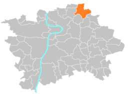 Location of Čakovice in Prague | |||
| Website: http://www.cakovice.cz | |||

Čakovice (German Tschakowitz) is a municipal district (městská část) in Prague. It is located in the north-eastern part of the city. As of 2008, there were 8,644 inhabitants living in Čakovice. The municipal district consists of three cadastral areas (katastrální území): Čakovice, Miškovice and Třeboradice.
The Čakovice cadastre has an area of 3.83 km2 and a population of 6,417 inhabitants.
The first written record of Čakovice is from the 11th century. The town became part of Prague in 1968.
External links
| Wikimedia Commons has media related to Čakovice. |
This article is issued from Wikipedia - version of the 5/18/2016. The text is available under the Creative Commons Attribution/Share Alike but additional terms may apply for the media files.