Čagona
| Čagona | |
|---|---|
 Čagona Location in Slovenia | |
| Coordinates: 46°32′54.58″N 15°55′30.32″E / 46.5484944°N 15.9250889°ECoordinates: 46°32′54.58″N 15°55′30.32″E / 46.5484944°N 15.9250889°E | |
| Country |
|
| Traditional region | Styria |
| Statistical region | Drava |
| Municipality | Cerkvenjak |
| Area | |
| • Total | 3.34 km2 (1.29 sq mi) |
| Elevation | 267.8 m (878.6 ft) |
| Population (2002) | |
| • Total | 237 |
| [1] | |
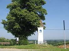
Plague columns in Čagona
Čagona (pronounced [ˈtʃaːɡɔna]) is a settlement in the Municipality of Cerkvenjak in northeastern Slovenia. It lies on the edge of the Slovene Hills (Slovene: Slovenske gorice) and partly in the Pesnica Valley. The area was part of the traditional region of Styria and is now included in the Drava Statistical Region.[2]
References
External links
| Wikimedia Commons has media related to Čagona. |
| Settlements | Administrative centre: Cerkvenjak
|  |
|---|---|---|
| Landmarks |
| |
This article is issued from Wikipedia - version of the 2/9/2015. The text is available under the Creative Commons Attribution/Share Alike but additional terms may apply for the media files.