Zell im Fichtelgebirge
| Zell im Fichtelgebirge | ||
|---|---|---|
| ||
 Zell im Fichtelgebirge | ||
Location of Zell im Fichtelgebirge within Hof district 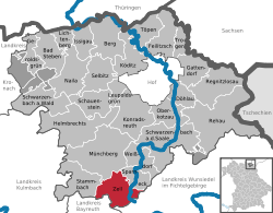 | ||
| Coordinates: 50°7′N 11°48′E / 50.117°N 11.800°ECoordinates: 50°7′N 11°48′E / 50.117°N 11.800°E | ||
| Country | Germany | |
| State | Bavaria | |
| Admin. region | Oberfranken | |
| District | Hof | |
| Government | ||
| • Mayor | Horst Penzel (ÜWG / Überparteiliche Wählergemeinschaft) | |
| Area | ||
| • Total | 31.24 km2 (12.06 sq mi) | |
| Population (2015-12-31)[1] | ||
| • Total | 2,005 | |
| • Density | 64/km2 (170/sq mi) | |
| Time zone | CET/CEST (UTC+1/+2) | |
| Postal codes | 95239 | |
| Dialling codes | 09257 | |
| Vehicle registration | HO | |
| Website | www.markt-zell.de | |

Zell im Fichtelgebirge, formerly Zell (official name until July 2007[2]) is a market town in the district of Hof in Bavaria in Germany.
Geography
The heart of the market parish lies between the towns of Hof and Bayreuth, about 5 km from the B 2 federal road and about 10 km from the A 9 motorway. The River Saale rises on the Waldstein ridge in the Fichtelgebirge near Zell im Fichtelgebirge. The surrounding area may explored on some 30 kilometres of signposted hiking trails.
References
- ↑ "Fortschreibung des Bevölkerungsstandes". Bayerisches Landesamt für Statistik und Datenverarbeitung (in German). June 2016.
- ↑ "Seit gestern Abend amtlich: Zell im Fichtelgebirge" (in German). Frankenpost. 2007-07-16. Retrieved 2007-08-02.
This article is issued from Wikipedia - version of the 5/20/2015. The text is available under the Creative Commons Attribution/Share Alike but additional terms may apply for the media files.