Yorke Peninsula Council
| Yorke Peninsula Council South Australia | |||||||||||||
|---|---|---|---|---|---|---|---|---|---|---|---|---|---|
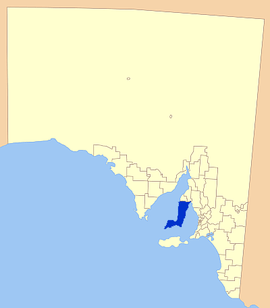 Location of the Yorke Peninsula Council | |||||||||||||
| Population | 11,018 (2015 est)[1] | ||||||||||||
| • Density | 1.88858/km2 (4.8914/sq mi) | ||||||||||||
| Established | 1997 | ||||||||||||
| Area | 5,834 km2 (2,252.5 sq mi) | ||||||||||||
| Mayor | Ray Agnew[2] | ||||||||||||
| Council seat | Maitland | ||||||||||||
| Region | Yorke and Mid North[3] | ||||||||||||
| State electorate(s) | Goyder[4] | ||||||||||||
| Federal Division(s) | Grey[5] | ||||||||||||
|
| |||||||||||||
| Website | Yorke Peninsula Council | ||||||||||||
| |||||||||||||
The Yorke Peninsula Council is a local government area in South Australia. Its boundaries include most of the Yorke Peninsula. The council seat is at Maitland; the council also maintains branch offices at Minlaton, Warooka and Yorketown.[7]
It came into existence on 10 February 1997 as a result of the amalgamation of the District Council of Central Yorke Peninsula, the District Council of Minlaton, the District Council of Warooka and the District Council of Yorketown.[8] It was known as the District Council of Yorke Peninsula at its inception, but was renamed to Yorke Peninsula Council in 2013.[9]
Geography
It includes the towns and localities of
- Agery
- Ardrossan
- Arthurton
- Balgowan
- Black Point
- Bluff Beach
- Brentwood
- Chinaman Wells
- Clinton
- Clinton Centre
- Coobowie
- Corny Point
- Couch Beach
- Cunningham
- Curramulka
- Dowlingville
- Edithburgh
- Foul Bay
- Hardwicke Bay
- Honiton
- Inneston
- James Well
- Kainton
- Koolywurtie
- Maitland
- Marion Bay
- Minlaton
- Nalyappa
- Petersville
- Pine Point
- Point Pearce
- Point Souttar
- Point Turton
- Port Arthur
- Port Julia
- Port Moorowie
- Port Rickaby
- Port Victoria
- Port Vincent
- Price
- Ramsay
- Rogues Point
- Sandilands
- Sheaoak Flat
- South Kilkerran
- Stansbury
- Sultana Point
- Sunnyvale
- The Pines
- Tiddy Widdy Beach
- Urania
- Warooka
- Wauraltee
- Weetulta
- White Hut
- Winulta
- Wool Bay
- Yorke Valley
- Yorketown[10]
Councillors
| Ward | Councillor | Notes | |
|---|---|---|---|
| Mayor[2] | Ray Agnew | ||
| Gum Flat[2] | Naomi Bittner | ||
| Jeffrey Cook | |||
| Scott Hoyle | |||
| Innes Pentonvale[2] | Darren Braund | ||
| Veronica Brundell | |||
| Adam Meyer | |||
| John Rich | |||
| Kalkabury[2] | Trevor Davey | Deputy Mayor | |
| Alan Headon | |||
| David Langford | |||
| Tania Stock | |||
The Yorke Peninsula Council has a directly-elected mayor.[11]
Mayors of the Yorke Peninsula Council
References
- ↑ "3218.0 – Regional Population Growth, Australia, 2014–15". Australian Bureau of Statistics. Retrieved 29 September 2016.
- 1 2 3 4 5 "Elected Members". Yorke Peninsula Council. Retrieved 3 April 2016.
- ↑ "Yorke and Mid North SA Government region" (PDF). The Government of South Australia. Retrieved 10 October 2014.
- ↑ "Goyder electorate boundaries as of 2014". ELECTORAL COMMISSION SA. Retrieved 23 July 2015.
- ↑ "Federal electoral division of Grey" (PDF). Australian Electoral Commission. Retrieved 24 July 2015.
- 1 2 3 4 5 "Development Plan - Yorke Peninsula Council" (PDF). pp. 232&341. Archived from the original (PDF) on June 4, 2015. Retrieved 24 July 2015.
- ↑ "Branch Offices". Yorke Peninsula Council. Retrieved 3 April 2016.
- ↑ "Sewer and STED Sustainability – A District Council of Yorke Peninsula Success Story" (PDF). Local Government Association of South Australia. Retrieved 31 March 2016.
- ↑ "The South Australian Government Gazette 5 December 2013" (PDF). Government of South Australia. Retrieved 30 May 2016.
- ↑ "Location SA Map Viewer". Government of South Australia. Retrieved 3 April 2016.
- ↑ "Election Results 2014" (PDF). Local Government Association of South Australia. Retrieved 15 February 2016.
- ↑ "Maitland Matters: March 2014" (PDF). Maitland & District Progress Association. Retrieved 25 November 2016.
- ↑ Novak, Lauren (28 September 2006). "Record number want to be mayor". The Advertiser.
External links
| Major Townships | |||||||||||
|---|---|---|---|---|---|---|---|---|---|---|---|
| Minor Townships | |||||||||||
| Governance |
| ||||||||||
| Coastal features | |||||||||||
| Protected areas |
| ||||||||||
| Islands adjoining the Yorke Peninsula coast | |||||||||||
| Related and uncategorised | |||||||||||
| |||||||||||
Coordinates: 35°13′26″S 138°24′07″E / 35.2239°S 138.402°E