Wyaston
| Wyaston | |
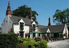 The Shire Horse, Wyaston |
|
 Wyaston |
|
| OS grid reference | SK184424 |
|---|---|
| District | Derbyshire Dales |
| Shire county | Derbyshire |
| Region | East Midlands |
| Country | England |
| Sovereign state | United Kingdom |
| Post town | ASHBOURNE |
| Postcode district | DE6 |
| Police | Derbyshire |
| Fire | Derbyshire |
| Ambulance | East Midlands |
| EU Parliament | East Midlands |
|
|
Coordinates: 52°58′44″N 1°43′37″W / 52.979°N 1.727°W
Wyaston is a hamlet in Derbyshire, England.[1] It is located 3 miles south of Ashbourne.
Wyaston is in the civil parish of Edlaston and Wyaston.[2]
References
- ↑ Ordnance Survey: Landranger map sheet 119 Buxton & Matlock (Chesterfield, Bakewell & Dove Dale) (Map). Ordnance Survey. 2012. ISBN 9780319231890.
- ↑ "Ordnance Survey Election Maps". www.ordnancesurvey.co.uk. Ordnance Survey. Retrieved 18 February 2016.
This article is issued from Wikipedia - version of the 3/23/2016. The text is available under the Creative Commons Attribution/Share Alike but additional terms may apply for the media files.