Wongarbon
| Wongarbon New South Wales | |
|---|---|
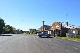 Main street | |
|
Wongarbon | |
| Coordinates | 32°20′0″S 148°46′0″E / 32.33333°S 148.76667°ECoordinates: 32°20′0″S 148°46′0″E / 32.33333°S 148.76667°E |
| Population | 449 (2006 census)[1] |
| Postcode(s) | 2831 |
| Location | |
| LGA(s) | Western Plains Regional Council |
| State electorate(s) | Dubbo |
| Federal Division(s) | Parkes |
Wongarbon is a small village approximately 18 kilometres east of Dubbo on the Mitchell Highway between Dubbo and Wellington, New South Wales, Australia. At the 2006 census, Wongarbon had a population of 449.[1]
The village has a three-teacher primary school, convenience store/post office and a pub.
Notes and references
- 1 2 Australian Bureau of Statistics (25 October 2007). "Wongarbon (L) (Urban Centre/Locality)". 2006 Census QuickStats. Retrieved 2 March 2010.
External links
![]() Media related to Wongarbon at Wikimedia Commons
Media related to Wongarbon at Wikimedia Commons
This article is issued from Wikipedia - version of the 8/28/2016. The text is available under the Creative Commons Attribution/Share Alike but additional terms may apply for the media files.