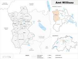
Willisau District
| Willisau District Wahlkreis Willisau | |
|---|---|
| District | |
 | |
| Country |
|
| Canton |
|
| Capital | Willisau |
| Area | |
| • Total | 336.99 km2 (130.11 sq mi) |
| Population (2015) | |
| • Total | 52,594 |
| • Density | 160/km2 (400/sq mi) |
| Time zone | CET (UTC+1) |
| • Summer (DST) | CEST (UTC+2) |
| Municipalities | 23 |
Willisau District is one of the five districts (German: Ämter), of the German-speaking Canton of Lucerne, Switzerland. Its capital is the town of Willisau. It has a population of 52,594 (as of 31 December 2015). In 2013 the name was changed from Amt Willisau to Wahlkreis Willisau as part of a reorganization of the Canton. A sixth Wahlkreis was created, but in Willisau everything else remained essentially unchanged.
Willisau District consists of the following municipalities:
| Municipality | Population (31 December 2015)[1] |
Area, km² |
|---|---|---|
| Alberswil | 656 | 3.6 |
| Altbüron | 986 | 6.8 |
| Altishofen | 1,555 | 5.7 |
| Dagmersellen | 5,234 | 23.9 |
| Ebersecken | 401 | 8.6 |
| Egolzwil | 1,420 | 4.2 |
| Ettiswil | 2,649 | 12.5 |
| Fischbach | 726 | 8.1 |
| Gettnau | 1,140 | 6.0 |
| Grossdietwil | 831 | 10.2 |
| Hergiswil bei Willisau | 1,887 | 31.3 |
| Luthern | 1,289 | 37.9 |
| Menznau | 2,884 | 30.4 |
| Nebikon | 2,565 | 3.7 |
| Pfaffnau | 2,529 | 17.6 |
| Reiden | 6,976 | 27.0 |
| Roggliswil | 661 | 6.2 |
| Schötz | 4,185 | 15.34 |
| Ufhusen | 892 | 12.3 |
| Wauwil | 1,978 | 2.9 |
| Wikon | 1,477 | 8.3 |
| Willisau | 7,676 | 41.2 |
| Zell | 1,997 | 13.9 |
| Total | 52,594 | 336.99[2]a |
- ^a 1992/97 survey gives a total area of 337.45 km2 (130.29 sq mi) without including certain large lakes, while the 2000 survey includes lakes but due to other changes is slightly lower.
References
- ↑ Swiss Federal Statistical Office - STAT-TAB, online database – Ständige und nichtständige Wohnbevölkerung nach institutionellen Gliederungen, Geburtsort und Staatsangehörigkeit (German) accessed 30 August 2016
- ↑ LUSTAT-Canton of Lucerne Statistical Office as of 2000 survey, (German) accessed 25 August 2009
Coordinates: 47°7′N 7°59′E / 47.117°N 7.983°E
This article is issued from Wikipedia - version of the 5/26/2015. The text is available under the Creative Commons Attribution/Share Alike but additional terms may apply for the media files.