Wiesengrund
| Wiesengrund | |
|---|---|
 Wiesengrund | |
Location of Wiesengrund within Spree-Neiße district 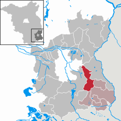 | |
| Coordinates: 51°42′00″N 14°34′00″E / 51.70000°N 14.56667°ECoordinates: 51°42′00″N 14°34′00″E / 51.70000°N 14.56667°E | |
| Country | Germany |
| State | Brandenburg |
| District | Spree-Neiße |
| Municipal assoc. | Döbern-Land |
| Government | |
| • Mayor | Egbert S. Piosik (FWW) |
| Area | |
| • Total | 50.08 km2 (19.34 sq mi) |
| Population (2015-12-31)[1] | |
| • Total | 1,390 |
| • Density | 28/km2 (72/sq mi) |
| Time zone | CET/CEST (UTC+1/+2) |
| Postal codes | 03149 |
| Dialling codes | 035694, 035695 |
| Vehicle registration | SPN |
Wiesengrund (Lower Sorbian Łukojce) is a municipality in the district of Spree-Neiße, in Brandenburg, Germany.
Demography
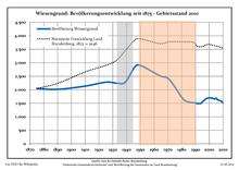
Development of Population since 1875 within the Current Boundaries (Blue Line: Population; Dotted Line: Comparison to Population Development of Brandenburg state; Grey Background: Time of Nazi rule; Red Background: Time of Communist rule)
|
|
|
|
Detailed data sources are to be found in the Wikimedia Commons.[3]
Subdivisions
The city districts are:
- Gahry (Gari)
- Gosda I (Gózna)
- Dubrau (Dubrawa)
- Klinge (Klinka)
- Jethe (Jaty)
- Smarso (Smaržow)
- Mattendorf (Matyjojce)
- Trebendorf (Trjebejce)
The Mattendorf district (Matyjojce) is a designated Sorbian settlement area (Sorbisches Siedlungsgebiet).
References
- ↑ "Bevölkerung im Land Brandenburg nach amtsfreien Gemeinden, Ämtern und Gemeinden 31. Dezember 2015 (Fortgeschriebene amtliche Einwohnerzahlen auf Grundlage des Zensus 2011)". Amt für Statistik Berlin-Brandenburg (in German). 2016.
- ↑ Boundaries as of 2013
- ↑ Population Projection Brandenburg at Wikimedia Commons
This article is issued from Wikipedia - version of the 6/21/2015. The text is available under the Creative Commons Attribution/Share Alike but additional terms may apply for the media files.