Waverbridge
| Waverbridge | |
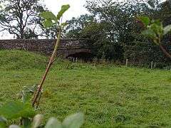 The sandstone bridge over the River Waver at Waverbridge. |
|
 Waverbridge |
|
| OS grid reference | NY223490 |
|---|---|
| Civil parish | Dundraw |
| District | Allerdale |
| Shire county | Cumbria |
| Region | North West |
| Country | England |
| Sovereign state | United Kingdom |
| Post town | WIGTON |
| Postcode district | CA7 |
| Dialling code | 016973 |
| Police | Cumbria |
| Fire | Cumbria |
| Ambulance | North West |
| EU Parliament | North West England |
| UK Parliament | Workington |
Coordinates: 54°49′48″N 3°12′32″W / 54.830°N 3.209°W
Waverbridge is a hamlet in the civil parish of Dundraw, right on the boundary with the civil parish of Waverton[1] in Cumbria, United Kingdom. It is located approximately two-and-three-quarter miles north-west of Wigton, three-and-three-quarter miles south-east of Abbeytown, and seven-and-a-half miles north-east of Aspatria. Carlisle, Cumbria's county town, is situated fourteen-and-a-quarter miles to the north-east. The B5302 road runs through the settlement, between Silloth-on-Solway in the west and Wigton in the east.[2]
The hamlet is named for its bridge over the River Waver. Historically there was a mill in Waverbridge,[3] which in 2010 was converted into a care home for children.[4] The conversion proved controversial both with residents of the village and with Dundraw parish council, citing concerns about anti-social behaviour and that a small village was not well-suited to housing teenagers.[5]
References
| Wikimedia Commons has media related to Waverbridge. |
- ↑ "Cumbria Observatory - Waverbridge (with parish boundaries enabled)". Retrieved 3 March 2015.
- ↑ "Google Maps - Waverbridge". Retrieved 3 March 2015.
- ↑ "Old Cumbria Gazetteer - Waverbridge Mill". Retrieved 3 March 2015.
- ↑ "Allerdale BC - Planning application for Waverbridge Mill". Retrieved 3 March 2015.
- ↑ "Cumberland News - Children's care home near Wigton given go-ahead". Retrieved 3 March 2015.