Vriescheloo
| Vriescheloo | |
|---|---|
| Village | |
|
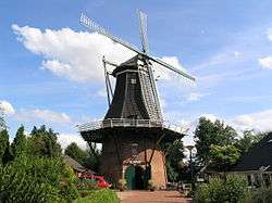
Smock mill De Korenbloem in 2008 | |
 Vriescheloo Location of Vriescheloo in the province of Groningen | |
| Coordinates: 53°4′5″N 7°6′50″E / 53.06806°N 7.11389°ECoordinates: 53°4′5″N 7°6′50″E / 53.06806°N 7.11389°E | |
| Country | Netherlands |
| Province | Groningen |
| Municipality | Bellingwedde |
| Area (2012)[1] | |
| • Total | 213 ha (526 acres) |
| • Land | 212 ha (524 acres) |
| • Water | 1 ha (2 acres) |
| Population (2012)[1] | |
| • Total | 705 |
| • Density | 330/km2 (860/sq mi) |
| Postcode | 9599[2] |
| Area code | 0597 |
Vriescheloo (Dutch pronunciation: [ˈvrisəˌloː]; Gronings: Vraiskeloo) is a village in the municipality of Bellingwedde in the Netherlands. It has a population of 705 and a total area of 213 ha (530 acres).[1]
 Map of Bellingwedde with Vriescheloo in red
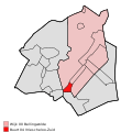 Map of Bellingwedde with Vriescheloo-Zuid in red
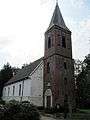 Church in c. 2011
References
- 1 2 3 (Dutch) Kerncijfers wijken en buurten 2009-2012, Statistics Netherlands, 2014. Retrieved on 27 April 2014.
- ↑ (Dutch) Resultaten voor "Vriescheloo,", Postcode.nl. Retrieved on 27 April 2014.
External links
-
 Media related to Vriescheloo at Wikimedia Commons
 |
Blijham | Oudeschans | Bellingwolde | |
| |
||||
| ||||
| | ||||
| Wedde | Veelerveen |
This article is issued from Wikipedia - version of the 5/25/2016. The text is available under the Creative Commons Attribution/Share Alike but additional terms may apply for the media files.