Vila Nova (Praia da Vitória)
| Vila Nova | |
| Civil Parish | |
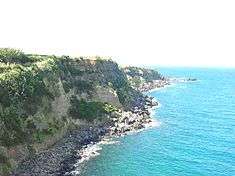 Praia das Escaleiras, on the northern coast of Vila Nova | |
| Official name: Freguesia da Vila Nova | |
| Name origin: Portuguese for new town | |
| Country | |
|---|---|
| Autonomous Region | |
| Island | Terceira |
| Municipality | Praia da Vitória |
| Localities | Alminhas, Canada da Bezerra, Canada da Estaca, Canada do Boqueiro, Faias, Nossa Senhora da Ajuda, Ribeira de Agualva, Vila Nova |
| Landmark | Ribeira de Agualva Watermill |
| Rivers | Ribeira das Pedras, Ribeira de Agualva |
| Center | Vila Nova |
| - elevation | 56 m (184 ft) |
| - coordinates | 38°46′51″N 27°8′43″W / 38.78083°N 27.14528°WCoordinates: 38°46′51″N 27°8′43″W / 38.78083°N 27.14528°W |
| Highest point | Canada do Boqueiro |
| - elevation | 135 m (443 ft) |
| - coordinates | 38°45′57″N 27°9′6″W / 38.76583°N 27.15167°W |
| Lowest point | Sea level |
| - location | Atlantic Ocean |
| - elevation | 0 m (0 ft) |
| Area | 8.14 km2 (3 sq mi) |
| - water | .00 km2 (0 sq mi) |
| - urban | .99 km2 (0 sq mi) |
| Population | 1,678 (2011) |
| Density | 206/km2 (534/sq mi) |
| LAU | Junta Freguesia |
| - location | Caminho da Abrigada, Estarada Regional E.R.1-1 |
| - coordinates | 38°46′50″N 27°9′9″W / 38.78056°N 27.15250°W |
| Timezone | Azores (UTC-1) |
| - summer (DST) | Azores (UTC0) |
| Postal Zone | 9760-701 |
| Area Code & Prefix | (+351) 292 XXX XXX |
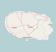 Location of the parish seat of Vila Nova on the island of Terceira | |
| Wikimedia Commons: Vila Nova (Praia da Vitória) | |
| Geographic detail from Instituto Geográfico Português (2010) | |
Vila Nova is a civil parish in the municipality of Praia da Vitória on the island of Terceira in the Portuguese Azores. The population in 2011 was 1,678,[1] in an area of 8.14 km².[2]
History
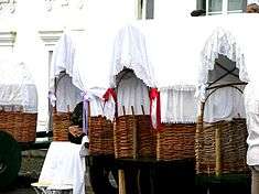
Allegorical carts during the Festas do Espírito Santo in Vila Nova
In its early settlement, the area of Vila Nova was known for its abundance of water; in 1891 there were 14 water fountains supplying potable water to the community. Although primarily a subsistence agriculture community, dominated by the harvesting of cereal crops, the area was also a refuge and settlement for many noble families.
Geography
The area is characterized by rocky coastal zone, that includes the bay and beach of Praia das Escaleiras, and a more elevated area that includes prime agricultural lands in Alminhas, Canada do Boqueiro and Canada da Bezerra.
Ecoregions/Protected areas
- Praia das Escaleiras
- Calvário
Architecture
Civic
- Chafariz da Canada da Bezerra
- Chafariz do Pico da Rocha
- Watermill of Agualva (Portuguese: Azenha da Ribeira de Agualva)
Religious
- Igreja Paroquial do Divino Espírito Santo
- Império do Divino Espírito Santo
- Ermida de Nossa Senhora da Ajuda
References
- ↑ Instituto Nacional de Estatística
- ↑ Eurostat Archived September 6, 2014, at the Wayback Machine.
This article is issued from Wikipedia - version of the 11/14/2016. The text is available under the Creative Commons Attribution/Share Alike but additional terms may apply for the media files.