Utkinton
| Utkinton | |
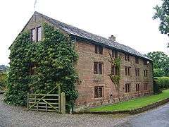 Bailiff's House |
|
 Utkinton |
|
| Population | 706 (2011 Census) |
|---|---|
| Civil parish | Utkinton |
| Unitary authority | Cheshire West and Chester |
| Ceremonial county | Cheshire |
| Region | North West |
| Country | England |
| Sovereign state | United Kingdom |
| Post town | TARPORLEY |
| Postcode district | CW6 |
| Dialling code | 01829 |
| Police | Cheshire |
| Fire | Cheshire |
| Ambulance | North West |
| EU Parliament | North West England |
| UK Parliament | Eddisbury |
Coordinates: 53°11′00″N 2°41′00″W / 53.183333°N 2.683333°W
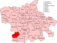
Map of civil parish of Utkinton within the former borough of Vale Royal
Utkinton is a civil parish and small village in the unitary authority of Cheshire West and Chester and the ceremonial county of Cheshire, England. It is approximately 8 miles west of Winsford and north of Tarporley and 9 miles east of Chester. Utkinton is at the heart of the local farming community. The upper part of Utkinton is known as 'Quarry Bank'.
It has a small population of around 600, measured at 706 at the 2011 census.[1] There is a shop, with a cafe and garden centre, a small Church of England school, a church and a Methodist Chapel that has fallen into disuse.
Utkinton is on the Sandstone Trail.
See also
References
- ↑ "Parish population 2011". Retrieved 30 May 2015.
External links
| Wikimedia Commons has media related to Utkinton. |
Cheshire Portal | |
| Unitary authorities | |
| Major settlements | |
| Rivers | |
| Topics | |
This article is issued from Wikipedia - version of the 1/23/2016. The text is available under the Creative Commons Attribution/Share Alike but additional terms may apply for the media files.