Trewidland
| Trewidland | |
| Cornish: Trewythelan | |
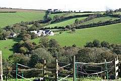 A view north of Trewidland |
|
 Trewidland |
|
| OS grid reference | SX255598 |
|---|---|
| Civil parish | Dobwalls and Trewidland |
| Unitary authority | Cornwall |
| Ceremonial county | Cornwall |
| Region | South West |
| Country | England |
| Sovereign state | United Kingdom |
| EU Parliament | South West England |
Coordinates: 50°24′43″N 4°27′25″W / 50.412°N 4.457°W
Trewidland (Cornish: Trewythelan)[1] is a hamlet in the civil parish of Dobwalls and Trewidland in east Cornwall, England. It is about two miles northeast of Duloe.[2]
References
| Wikimedia Commons has media related to Dobwalls and Trewidland. |
- ↑ Place-names in the Standard Written Form (SWF) : List of place-names agreed by the MAGA Signage Panel. Cornish Language Partnership.
- ↑ Ordnance Survey One-inch Map of Great Britain; Bodmin and Launceston, sheet 186. 1961.
Cornwall Portal | |
| Unitary authorities | |
| Major settlements |
|
| Rivers | |
| Topics | |
This article is issued from Wikipedia - version of the 10/2/2016. The text is available under the Creative Commons Attribution/Share Alike but additional terms may apply for the media files.