Topolovo
| Topolovo | |
|---|---|
 Topolovo Location in Slovenia | |
| Coordinates: 46°6′18.13″N 15°29′11.84″E / 46.1050361°N 15.4866222°ECoordinates: 46°6′18.13″N 15°29′11.84″E / 46.1050361°N 15.4866222°E | |
| Country |
|
| Traditional region | Styria |
| Statistical region | Savinja |
| Municipality | Kozje |
| Area | |
| • Total | 1.39 km2 (0.54 sq mi) |
| Elevation | 436.9 m (1,433.4 ft) |
| Population (2002) | |
| • Total | 45 |
| [1] | |
Topolovo (pronounced [tɔpɔˈlɔːʋɔ] or [tɔpɔˈloːʋɔ]) is a dispersed settlement in the Municipality of Kozje in eastern Slovenia. It lies in the Sava Hills (Slovene: Posavsko hribovje), west of Lesično. The area is part of the historical Styria region and is included in the Savinja Statistical Region.[2]
References
External links
| Settlements | 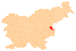 | |
|---|---|---|
| Landmarks |
| |
This article is issued from Wikipedia - version of the 1/4/2016. The text is available under the Creative Commons Attribution/Share Alike but additional terms may apply for the media files.