Taschagil
Coordinates: 48°52′31″N 52°58′15″E / 48.87528°N 52.97083°E
| Taschagil Тасшағыл Тасшагил تاسشاعىل | |
|---|---|
 Taschagil | |
| Coordinates: 48°52′31″N 52°58′15″E / 48.87528°N 52.97083°E | |
| Country |
|
| Region | Atyrau |
| Elevation | 16 m (52 ft) |
| Time zone | West Kazakhstan Time (UTC+5) |
| • Summer (DST) | West Kazakhstan Time (UTC+5) |
Taschagil (also known as Tasshagyl[1] (Russian: Тасшагил, Tasshagil, Kazakh: Тасшағыл, Tasşağıl, تاسشاعىل)) is a town in Atyrau Region, west Kazakhstan. It lies at an altitude of 16 m (52 ft).[1]
References
- 1 2 "Taschagil, Kazakhstan - P PPL 608080". GeoNames. Retrieved September 25, 2016.
Capital: Atyrau | ||
| Districts | 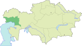 | |
| Major cities | ||
| Towns and villages |
| |
This article is issued from Wikipedia - version of the 9/25/2016. The text is available under the Creative Commons Attribution/Share Alike but additional terms may apply for the media files.