Tacheng Prefecture
| Tacheng Prefecture 塔城地区 • تارباعاتاي ايماعى • تارباغاتاي ۋىلايىتى (Chinese) • (Uyghur) • (Kazakh) | |
|---|---|
| Prefecture | |
|
Usu in Tacheng Prefecture | |
 Tacheng prefecture (red) in Ili prefecture (light red) and Xinjiang (orange) | |
| Country | People's Republic of China |
| Province | Xinjiang |
| Sub-provincial | Ili Prefecture |
| Time zone | China Standard (UTC+8) |
| Website |
xjtc |
| Tarbagatai Prefecture | |||||||||||||
| Chinese name | |||||||||||||
|---|---|---|---|---|---|---|---|---|---|---|---|---|---|
| Chinese | 塔城地区 | ||||||||||||
| |||||||||||||
| Uyghur name | |||||||||||||
| Uyghur |
تارباغاتاي ۋىلايىتى | ||||||||||||
| |||||||||||||
| Kazakh name | |||||||||||||
| Kazakh |
تارباعاتاي ايماعى Tarbağatay aymağı Тарбағатай аймағы | ||||||||||||
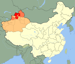
Tacheng (Tarbagatay) Prefecture is located in northern Xinjiang, People's Republic of China. It has an area of 98,824 km2 (38,156 sq mi) and a population of 892,397 (2000). It is a part of Ili Kazakh Autonomous Prefecture. The prefecture level city of Karamay forms a separate enclave in the middle of Tacheng.
Subdivisions
Tacheng prefecture is divided into 2 county level cities, 4 counties, and 1 autonomous county.
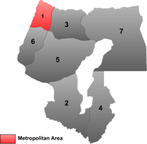 | ||||||||||
| # | Name | Hanzi | Hanyu Pinyin | Uyghur (UEY) | Uyghur Latin (ULY) | Kazakh (Arabic script) | Kazakh Latin transcription | Population (2010 Census) | Area (km²) | Density (/km²) |
|---|---|---|---|---|---|---|---|---|---|---|
| 1 | Tacheng [Qoqek] | 塔城市 | Tǎchéng Shì | چۆچەك شەھىرى | Chöchek Shehiri | شاۋەشەك قالاسى | Şäwesek qalası | 161,037 | 4,007 | 40.18 |
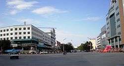
| 2 | Usu | 乌苏市 | Wūsū Shì | ۋۇسۇ شەھىرى | Usu Shehiri | شيحۋ قالاسى | Şïxw qalası | 298,907 | 14,394 | 20.76 |
| 3 | Emin [Dorbiljin] County | 额敏县 | Émǐn Xiàn | دۆربىلجىن ناھىيىسى | Dörbiljin Nahiyisi | ءدوربىلجىن اۋدانى | Dörbiljin awdanı | 187,112 | 9,147 | 20.45 |
| 4 | Shawan County | 沙湾县 | Shāwān Xiàn | ساۋەن ناھىيىسى | Saven Nahiyisi | ساۋان اۋدانى | Sawan awdanı | 365,196 | 12,460 | 29.30 |
| 5 | Toli County | 托里县 | Tuōlǐ Xiàn | تولى ناھىيىسى | Toli Nahiyisi | تولى اۋدانى | Tolı awdanı | 93,098 | 19,992 | 4.65 |
| 6 | Yumin County | 裕民县 | Yùmín Xiàn | چاغانتوقاي ناھىيىسى | Chaghantoqay Nahiyisi | شاعانتوعاي اۋدانى | Şağantoğay awdanı | 51,919 | 6,107 | 8.50 |
| 7 | Hoboksar Mongol Autonomous County | 和布克赛尔蒙古自治县 | Hébùkèsài'ěr Měnggǔ Zìzhìxiàn | ئاپتونوم ناھىيىسى قوبۇقسار موڭغۇل | Qobuqsar Mongghul Aptonom Nahiyisi | قوبىقسارى موڭعۇل اۆتونوميالى اۋدانى | Qobıqsarı Moñğul avtonomyalı awdanı | 62,100 | 28,784 | 2.15 |
Geography
See Emin Valley, Tarbagatai Mountains, Saur Mountains, Gurbantünggüt Desert.
See also
Coordinates: 45°49′59″N 84°49′59″E / 45.833°N 84.833°E
This article is issued from Wikipedia - version of the 8/19/2016. The text is available under the Creative Commons Attribution/Share Alike but additional terms may apply for the media files.