Administrative divisions of Croatia
The subdivisions of Croatia on the first level are the 20 counties (županija, pl. županije) and one city-county (grad, "city"). On the second level these are municipalities (općina, pl. općine) and cities (grad, pl. gradovi). Both of these types of subdivisions encompass one or multiple settlements (naselje, pl. naselja).
Modern (1992–present)
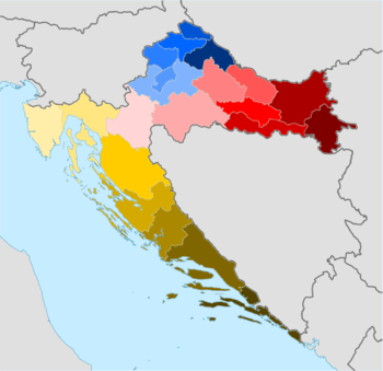
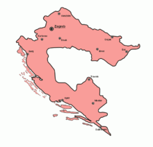
Counties of Croatia: Bjelovar-Bilogora Brod-Posavina Dubrovnik-Neretva Istria Karlovac Koprivnica-Križevci Krapina-Zagorje Lika-Senj Međimurje Osijek-Baranja Požega-Slavonia Primorje-Gorski Kotar Šibenik-Knin Sisak-Moslavina Split-Dalmatia Varaždin Virovitica-Podravina Vukovar-Syrmia Zadar City of Zagreb Zagreb County
- Counties (21)
- Municipalities (428)[1]
- Settlements (6,749)
1975–1990
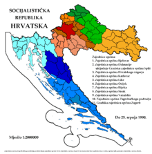
Unions of municipalities (1986-1990)
- Unions of Municipalities (9)
- Municipalities
- Settlements
1949–1951
- Oblasts
- Bjelovar
- Karlovac
- Osijek
- Rijeka
- Split
- Zagreb
1941–1945
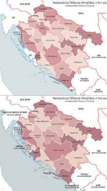
Independent State of Croatia, counties:
1941-1943 (1st)
1943-1944 (2nd)
1941-1943 (1st)
1943-1944 (2nd)
- Counties (22)
- Baranja
- Bilogora
- Bribir and Sidraga
- Cetina
- Dubrava
- Gora
- Hum
- Krbava - Psat
- Lašva and Glaž
- Lika and Gacka
- Livac and Zapolje
- Modruš
- Pliva and Rama
- Pokupje
- Posavje
- Prigorje
- Sana and Luka
- Usora and Soli
- Vinodol and Podgorje
- Vrhbosna
- Vuka
- Zagorje
- Zagreb
- Districts
- Municipalities
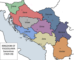
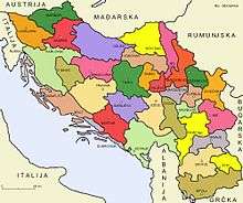
Sava and Littoral Banovina (red and blue)
Banovina of Croatia
1929–1941
1922–1929
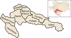
Dubrovnik-grey, Karlovac-green, Osijek-purple, Split and Vukovar-brown, Zagreb-red
- Oblasts
- Oblast of Dubrovnik
- Oblast of Karlovac
- Oblast of Osijek
- Oblast of Split
- Oblast of Vukovar (partially)
- Oblast of Zagreb
Kingdom of Croatia-Slavonia (1868–1922)
Counties in the Kingdom of Croatia-Slavonia
Medieval Croatian Kingdom
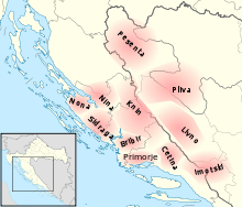
Approximate positions of the first counties of 10th century Croatia, overlaid on a map of modern Croatia and Bosnia-Herzegovina
- Counties[2]
- Livno
- Cetina
- Imotski
- Pliva
- Pesenta
- Klis
- Bribir
- Nin
- Knin
- Sidraga
- Luka
See also
- Counties of Croatia
- Counties of the Independent State of Croatia
- Former counties of Croatia (in Kingdom of Croatia-Slavonia)
- Municipalities of Croatia
- ISO 3166-2 codes of Croatia
- FIPS region codes of Croatia (standard withdrawn in 2008)
- NUTS of Croatia
References
- ↑ "Popis gradova i općina" (Microsoft Excel). uprava.hr (in Croatian). Ministry of Public Administration, Croatia. 10 June 2013. Retrieved 2 December 2015.
- ↑ Vrbošić, Josip. POVIJESNI PREGLED RAZVITKA ŽUPANIJSKE UPRAVE I SAMOUPRAVE U HRVATSKOJ, University of Osijek.
This article is issued from Wikipedia - version of the 10/4/2016. The text is available under the Creative Commons Attribution/Share Alike but additional terms may apply for the media files.