Spodnja Korena
| Spodnja Korena | |
|---|---|
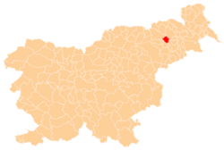
 Spodnja Korena Location in Slovenia | |
| Coordinates: 46°30′49.75″N 15°45′34.25″E / 46.5138194°N 15.7595139°ECoordinates: 46°30′49.75″N 15°45′34.25″E / 46.5138194°N 15.7595139°E | |
| Country |
|
| Traditional region | Styria |
| Statistical region | Drava |
| Municipality | Duplek |
| Area | |
| • Total | 3.04 km2 (1.17 sq mi) |
| Elevation | 274.6 m (900.9 ft) |
| Population (2002) | |
| • Total | 409 |
| [1] | |
Spodnja Korena (pronounced [ˈspoːdnja ˈkoːɾɛna]) is a settlement in the Municipality of Duplek in northeastern Slovenia. It lies on the southwestern edge of the Slovene Hills (Slovene: Slovenske gorice) southeast of Maribor. The area is part of the traditional region of Styria. The municipality is now included in the Drava Statistical Region.[2]
A site of a Roman-era limestone quarry has been identified near the settlement.[3]
References
External links
| Settlements | Administrative centre: Spodnji Duplek
|  | ||||||
|---|---|---|---|---|---|---|---|---|
This article is issued from Wikipedia - version of the 7/18/2015. The text is available under the Creative Commons Attribution/Share Alike but additional terms may apply for the media files.