Simmerath
| Simmerath | ||
|---|---|---|
| ||
 Simmerath | ||
Location of Simmerath within Aachen district 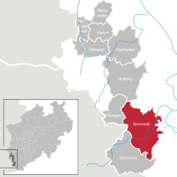 | ||
| Coordinates: 50°36′00″N 06°17′59″E / 50.60000°N 6.29972°ECoordinates: 50°36′00″N 06°17′59″E / 50.60000°N 6.29972°E | ||
| Country | Germany | |
| State | North Rhine-Westphalia | |
| Admin. region | Köln | |
| District | Aachen | |
| Government | ||
| • Mayor | Hubert Breuer (CDU) | |
| Area | ||
| • Total | 111.430 km2 (43.023 sq mi) | |
| Population (2015-12-31)[1] | ||
| • Total | 15,266 | |
| • Density | 140/km2 (350/sq mi) | |
| Time zone | CET/CEST (UTC+1/+2) | |
| Postal codes | 52152 | |
| Dialling codes | 02473 | |
| Vehicle registration | AC, MO | |
| Website | www.simmerath.de | |

Simmerath is a municipality in the district of Aachen, in North Rhine-Westphalia, Germany. It is located approximately 20 km south-east of Aachen, near the border to Belgium.
The administrative area was expanded in 1972 and includes the following localities:
- Dedenborn
- Eicherscheid
- Einruhr
- Erkensruhr
- Hammer
- Hirschrott
- Huppenbroich
- Kesternich
- Lammersdorf
- Paustenbach
- Rollesbroich
- Rurberg
- Simmerath
- Steckenborn
- Strauch
- Witzerath
- Woffelsbach
Gallery
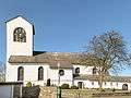 Simmerath, church
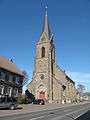 Lammersdorf, church
References
- ↑ "Amtliche Bevölkerungszahlen". Landesbetrieb Information und Technik NRW (in German). 18 July 2016.
Towns and municipalities in Aachen (district) | ||
|---|---|---|
This article is issued from Wikipedia - version of the 10/6/2016. The text is available under the Creative Commons Attribution/Share Alike but additional terms may apply for the media files.