Shaykh Hilal
| Shaykh Hilal الشيخ هلال | |
|---|---|
| Village | |
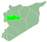
 Shaykh Hilal Location in Syria | |
| Coordinates: 35°14′58″N 37°30′18″E / 35.24944°N 37.50500°ECoordinates: 35°14′58″N 37°30′18″E / 35.24944°N 37.50500°E | |
| Country |
|
| Governorate | Hama |
| District | Salamiyah |
| Subdistrict | Saan |
| Population (2004) | |
| • Total | 834 |
| Time zone | EET (UTC+2) |
| • Summer (DST) | EEST (UTC+3) |
| City Qrya Pcode | C3281 |
Shaykh Hilal (Arabic: الشيخ هلال) is a Syrian village located in Al-Saan Nahiyah in Al-Salamiyah District, Hama. According to the Syria Central Bureau of Statistics (CBS), Shaykh Hilal had a population of 834 in the 2004 census.[1] Its inhabitants are predominantly Ismailis.
References
- ↑ "General Census of Population 2004.". Retrieved 2014-07-10.
This article is issued from Wikipedia - version of the 9/18/2015. The text is available under the Creative Commons Attribution/Share Alike but additional terms may apply for the media files.