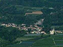
Sanzeno
For other uses, see San Zeno (disambiguation) and San Zeno.
| Sanzeno | |
|---|---|
| Comune | |
| Comune di Sanzeno | |
 | |
 Sanzeno Location of Sanzeno in Italy | |
| Coordinates: 46°22′N 11°4′E / 46.367°N 11.067°ECoordinates: 46°22′N 11°4′E / 46.367°N 11.067°E | |
| Country | Italy |
| Region | Trentino-Alto Adige/Südtirol |
| Province / Metropolitan city | Trentino (TN) |
| Frazioni | Banco, Casez, Piano |
| Government | |
| • Mayor | Marcello Bonadiman |
| Area | |
| • Total | 8.0 km2 (3.1 sq mi) |
| Elevation | 641 m (2,103 ft) |
| Population (Dec. 2004) | |
| • Total | 948 |
| • Density | 120/km2 (310/sq mi) |
| Demonym(s) | Sanzenesi |
| Time zone | CET (UTC+1) |
| • Summer (DST) | CEST (UTC+2) |
| Postal code | 38010 |
| Dialing code | 0463 |
| Website | Official website |
Sanzeno (Italian: [sanˈdzeːno], German: Sanzinnen am Nonsberg, Ladin: Sanzen) is a comune (municipality) in Trentino in the northern Italian region Trentino-Alto Adige/Südtirol, located about 35 kilometres (22 mi) north of Trento. As of 31 December 2004, it had a population of 948 and an area of 8.0 square kilometres (3.1 sq mi).[1]
Geography
The municipality of Sanzeno contains the frazioni (subdivisions, mainly villages and hamlets) of Banco, Casez and Piano.
Sanzeno borders the following municipalities: Cles, Coredo, Dambel, Revò, Romallo, Romeno, Taio and Tassullo.
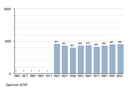
Demographic evolution
References
External links
![]() Media related to Sanzeno at Wikimedia Commons
Media related to Sanzeno at Wikimedia Commons

This article is issued from Wikipedia - version of the 11/12/2015. The text is available under the Creative Commons Attribution/Share Alike but additional terms may apply for the media files.