River Thet
| Thet | |
| River | |
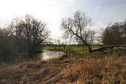 River Thet at Brettenham | |
| Country | England |
|---|---|
| Region | Norfolk |
| Part of | River Little Ouse |
| Source | |
| - location | Deopham Green |
| - elevation | 53 m (174 ft) |
| - coordinates | 52°33′03″N 1°00′07″E / 52.5507°N 1.0019°E |
| Mouth | River Little Ouse |
| - location | Thetford |
| - elevation | 10 m (33 ft) |
| - coordinates | 52°24′41″N 0°44′55″E / 52.4113°N 0.7485°ECoordinates: 52°24′41″N 0°44′55″E / 52.4113°N 0.7485°E |
| Length | 34.3 km (21 mi) |
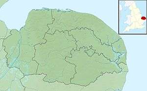 Location of the river mouth within Norfolk | |
The River Thet is a river in Norfolk, England and is a tributary of the River Little Ouse.
It rises in Breckland with sources in Deopham Green and Rockland All Saints[1] and joins the Little Ouse in Thetford.[2]
References
This article is issued from Wikipedia - version of the 12/3/2016. The text is available under the Creative Commons Attribution/Share Alike but additional terms may apply for the media files.